IMAGES TAKEN NEAR TO
Pinfold Crescent, WOLVERHAMPTON, WV4 4ET
Introduction
This page details the photographs taken nearby to Pinfold Crescent, WV4 4ET by members of the Geograph project.
The Geograph project started in 2005 with the aim of publishing, organising and preserving representative images for every square kilometre of Great Britain, Ireland and the Isle of Man.

There are currently over 7.5m images from over14,400 individuals and you can help contribute to the project by visiting https://www.geograph.org.uk
Image Map
Images are licensed for reuse under creativecommons.org/licenses/by-sa/2.0
Notes
- Clicking on the map will re-center to the selected point.
- The higher the marker number, the further away the image location is from the centre of the postcode.
Image Listing (44 Images Found)
Images are licensed for reuse under creativecommons.org/licenses/by-sa/2.0
Image
Details
Distance
1
Pinfold Crescent
The view in Lower Penn, Wolverhampton.
Image: © Gordon Griffiths
Taken: 13 Jul 2019
0.03 miles
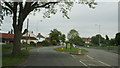
2
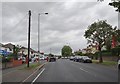
Warstones Road
The view in Merry Hill, Wolverhampton.
Image: © Gordon Griffiths
Taken: 21 Aug 2020
0.07 miles
3

Football training on the Recreation Ground
A busy Saturday morning at the recreation ground off Pinfold Lane.
Image: © John M
Taken: 2 Dec 2006
0.11 miles
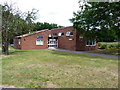
4
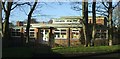
Warstones Primary School
Classrooms and exit at the back of the school.
Image: © John M
Taken: 2 Dec 2006
0.14 miles
5

Not Flying any more...
Times do not look good at the former Flying Dutchman pub on Warstones Drive. The name of the pub may be related to the fact that Dutch soldiers were stationed at Wrottesley Park in the latter years of WW2. Or it may just be in honour of the railway engine.
Image: © Richard Law
Taken: 5 Jul 2010
0.15 miles
6
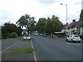
Warstones Road, Wolverhampton
Towards Merry Hill.
Image: © JThomas
Taken: 22 Aug 2019
0.15 miles
7
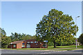
Warstones Library near Merry Hill in Wolverhampton
The library is at the junction of Warstones Drive with Pinfold Grove.
Image: © Roger Kidd
Taken: 17 Sep 2020
0.16 miles
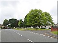
8
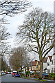
Housing and tall trees in Penn, Wolverhampton
Looking north-west towards Warstones, Pinfold Lane is quite a busy residential road linking the A449 Penn Road with Warstones and Merry Hill.
This Christmas Day 2022 image was taken soon after midday.
Image: © Roger Kidd
Taken: 25 Dec 2022
0.17 miles
10
Warstones Public Library
A small library on Pinfold Grove, Warstones
Image: © Richard Law
Taken: 5 Jul 2010
0.18 miles