IMAGES TAKEN NEAR TO
Clark Road, WOLVERHAMPTON, WV3 9PA
Introduction
This page details the photographs taken nearby to Clark Road, WV3 9PA by members of the Geograph project.
The Geograph project started in 2005 with the aim of publishing, organising and preserving representative images for every square kilometre of Great Britain, Ireland and the Isle of Man.

There are currently over 7.5m images from over14,400 individuals and you can help contribute to the project by visiting https://www.geograph.org.uk
Image Map
Images are licensed for reuse under creativecommons.org/licenses/by-sa/2.0
Notes
- Clicking on the map will re-center to the selected point.
- The higher the marker number, the further away the image location is from the centre of the postcode.
Image Listing (37 Images Found)
Images are licensed for reuse under creativecommons.org/licenses/by-sa/2.0
Image
Details
Distance
1
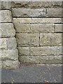
OS benchmark - Merridale, wall on Compton Road
An OS cutmark on the wall on the south side of Compton Road; originally levelled at 121.414m above Ordnance Datum Newlyn.
Image: © Richard Law
Taken: 3 Aug 2015
0.11 miles
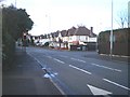
2
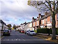
Paget Road
The view down the Wolverhampton street.
Image: © Gordon Griffiths
Taken: 6 Nov 2016
0.12 miles
3
Paget Road View
The view down the Wolverhampton street.
Image: © Gordon Griffiths
Taken: 27 Jul 2023
0.13 miles
4
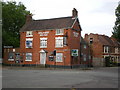
The Halfway House, Newbridge
This fine pub lies on the A41, an old coaching route through the Midlands. It owes its name to its position half way between London and Holyhead, and until recently had signage on the gable end announcing that it was 140 miles from each. It's to be hoped that it will re-open soon, as a local landmark such as this shouldn't be allowed to close and disappear for ever.
Image: © Richard Law
Taken: 28 Jul 2009
0.15 miles
5
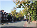
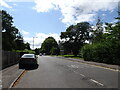
Tettenhall Road, Wolverhampton
This is the A41 road to Newport, Whitchurch and Chester. As Wolverhampton spread along this road in the late 19th and early 20th centuries, most of the dwellings were built for the more affluent members of society. The housing shown here on the south side of the road are far more modest than those on the north side, nearer West Park. Most of the grander premises are now divided into flats, or used for small businesses or offices.
Image: © Roger D Kidd
Taken: 13 Oct 2010
0.17 miles
6
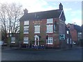
Halfway House
Undergoing conversion to a doctor's surgery and medical centre. Image
Image: © John M
Taken: 13 Feb 2014
0.17 miles
7
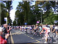
Tour passes through City
The Tour of Britain rides through Wolverhampton on the Compton Road.
Image: © Gordon Griffiths
Taken: 10 Sep 2008
0.17 miles
8
Tettenhall Road Scene
The view along the A41(Tettenhall Road) in Wolverhampton.
Image: © Gordon Griffiths
Taken: 20 Mar 2016
0.17 miles
9
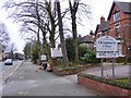
Traffic signals on the Compton Road
Straight on for Compton, turn right for Paget Road and access to the Tettenhall Road at the lights in Park Dale, beside Image
Image: © Richard Law
Taken: 29 Jan 2010
0.17 miles
10
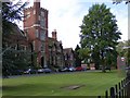
Wolverhampton Grammar
The School stands on the Compton Road.
Image: © Gordon Griffiths
Taken: 10 Sep 2008
0.18 miles