IMAGES TAKEN NEAR TO
Westland Road, WOLVERHAMPTON, WV3 9NY
Introduction
This page details the photographs taken nearby to Westland Road, WV3 9NY by members of the Geograph project.
The Geograph project started in 2005 with the aim of publishing, organising and preserving representative images for every square kilometre of Great Britain, Ireland and the Isle of Man.

There are currently over 7.5m images from over14,400 individuals and you can help contribute to the project by visiting https://www.geograph.org.uk
Image Map
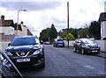
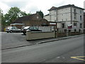
Images are licensed for reuse under creativecommons.org/licenses/by-sa/2.0
Notes
- Clicking on the map will re-center to the selected point.
- The higher the marker number, the further away the image location is from the centre of the postcode.
Image Listing (47 Images Found)
Images are licensed for reuse under creativecommons.org/licenses/by-sa/2.0
Image
Details
Distance
1
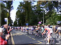
Tour passes through City
The Tour of Britain rides through Wolverhampton on the Compton Road.
Image: © Gordon Griffiths
Taken: 10 Sep 2008
0.06 miles
2
Wolverhampton Grammar
The School stands on the Compton Road.
Image: © Gordon Griffiths
Taken: 10 Sep 2008
0.06 miles
3
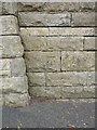
OS benchmark - Merridale, wall on Compton Road
An OS cutmark on the wall on the south side of Compton Road; originally levelled at 121.414m above Ordnance Datum Newlyn.
Image: © Richard Law
Taken: 3 Aug 2015
0.06 miles
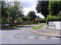
4
Merridale Lane Junction
The view in Merridale Wolverhampton alongside the Grammar School. The junction with Compton Road.
Image: © Gordon Griffiths
Taken: 5 Aug 2017
0.10 miles
5
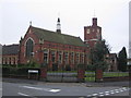
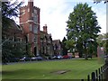
Wolverhampton Grammar School
Big School is the name given to Wolverhampton Grammar School's original Victorian Buildings. The foundation stone was laid on 10 April 1874 and the building was first occupied on 15 October 1875.
Now a fee paying school this was originally a grant maintained boys only grammar school. Its counterpart the council run Wolverhampton Girls High School avoided comprehensivisation.
Image: © Angella Streluk
Taken: 22 Apr 2006
0.11 miles
6
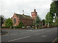
Wolverhampton Grammar School
Founded in 1512 as a free school (though it no longer is for most pupils), relocated from the city centre in 1875 to this site, subsequently much enlarged. The building shown here used to be nicknamed "Big School". As seen from the junction of Compton Road & Merridale Lane. http://www.wolverhamptongrammarschool.com/pages/prospective/history.aspx
Image: © Mike Faherty
Taken: 8 Jun 2009
0.11 miles
7
Westland Avenue
The view from Rupert Street in Wolverhampton.
Image: © Gordon Griffiths
Taken: 5 Aug 2017
0.11 miles
8
Merridale Lane View
The view in Merridale Wolverhampton alongside the Grammar School.
Image: © Gordon Griffiths
Taken: 5 Aug 2017
0.12 miles
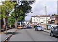
9
Rupert Street
The view in Merridale, Wolverhampton.
Image: © Gordon Griffiths
Taken: 5 Aug 2017
0.13 miles
10
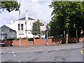
Wolverhampton, Wesleyan Holiness Church
In Merridale Lane. http://www.wesleyan.net/churches/wolverhampton_uk.html
Image: © Mike Faherty
Taken: 8 Jun 2009
0.14 miles