IMAGES TAKEN NEAR TO
Finchfield Hill, WOLVERHAMPTON, WV3 9HF
Introduction
This page details the photographs taken nearby to Finchfield Hill, WV3 9HF by members of the Geograph project.
The Geograph project started in 2005 with the aim of publishing, organising and preserving representative images for every square kilometre of Great Britain, Ireland and the Isle of Man.

There are currently over 7.5m images from over14,400 individuals and you can help contribute to the project by visiting https://www.geograph.org.uk
Image Map (Loading...)


Getting Data...Please wait
Leaflet Map data © OpenStreetMap
Images are licensed for reuse under creativecommons.org/licenses/by-sa/2.0
Notes
- Clicking on the map will re-center to the selected point.
- The higher the marker number, the further away the image location is from the centre of the postcode.
Image Listing (84 Images Found)
Images are licensed for reuse under creativecommons.org/licenses/by-sa/2.0
Image
Details
Distance
1
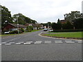
The Spinney
The view from Finchfield Hill in Compton, Wolverhampton.
Image: © Gordon Griffiths
Taken: 28 Sep 2020
0.03 miles
2
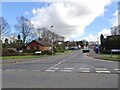
The Spinney View
The view from Finchfield Hill in Compton, Wolverhampton.
Image: © Gordon Griffiths
Taken: 26 Feb 2021
0.05 miles
3
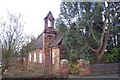
Redundant Church at Finchfield
The Church, in Oak Hill, was dedicated to St. Thomas. Now a listed building, it was closed and put up for sale in 2000 but no buyer has, as yet, been found
Image: © Geoff Pick
Taken: 25 Feb 2006
0.07 miles
4
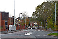
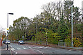
Finchfield Hill in Wolverhampton
Looking north towards Compton from the junction with Oak Hill and Finchfield Road West. The red-brick Lidl supermarket is off to the left.
Image: © Roger Kidd
Taken: 22 Nov 2022
0.15 miles
5
Finchfield Hill in Wolverhampton
This is the B4161, looking north towards Compton. Westacre Infant School is behind the trees on the right.
Image: © Roger Kidd
Taken: 22 Nov 2022
0.16 miles
6
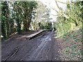
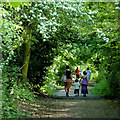
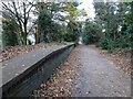
Old Station
The view of the Compton Halt on the South Staffordshire Railway Walk in Wolverhampton. The Halt was used from 1925 to 1932.
Image: © Gordon Griffiths
Taken: 11 Mar 2019
0.17 miles
7
Course of old railway at Compton, Wolverhampton
The railway, opened in 1925, ran from Wolverhampton to Stourbridge Junction. It was closed to passengers within 7 years. Read all about the whole line by going here http://www.railaroundbirmingham.co.uk/regional_map.php then clicking on each station.
Image: © Roger D Kidd
Taken: 17 May 2014
0.17 miles
8
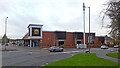
Lidl supermarket in Finchfield, Wolverhampton
Looking north-west from Finchfield Road West. Finchfield Hill leads towards Compton, off to the right.
Image: © Roger Kidd
Taken: 22 Nov 2022
0.17 miles
9
Platform Scene
The view of the Compton Halt on the South Staffordshire Railway Walk in Wolverhampton. The Halt was used from 1925 to 1932.
Image: © Gordon Griffiths
Taken: 23 Nov 2020
0.17 miles
10
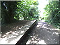
Railway Path Halt
The view of the Compton Halt on the South Staffordshire Railway Walk in Wolverhampton. The Halt was used from 1925 to 1932.
Image: © Gordon Griffiths
Taken: 15 May 2015
0.17 miles