IMAGES TAKEN NEAR TO
Compton Road West, WOLVERHAMPTON, WV3 9DW
Introduction
This page details the photographs taken nearby to Compton Road West, WV3 9DW by members of the Geograph project.
The Geograph project started in 2005 with the aim of publishing, organising and preserving representative images for every square kilometre of Great Britain, Ireland and the Isle of Man.

There are currently over 7.5m images from over14,400 individuals and you can help contribute to the project by visiting https://www.geograph.org.uk
Image Map
Images are licensed for reuse under creativecommons.org/licenses/by-sa/2.0
Notes
- Clicking on the map will re-center to the selected point.
- The higher the marker number, the further away the image location is from the centre of the postcode.
Image Listing (67 Images Found)
Images are licensed for reuse under creativecommons.org/licenses/by-sa/2.0
Image
Details
Distance
1
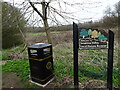
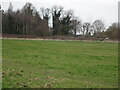
Smestow Valley Local Nature Reserve View
The view of the Valley Park nature reserve off Compton Hill Drive in Compton, Wolverhampton.
Image: © Gordon Griffiths
Taken: 21 Mar 2022
0.13 miles
2
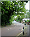
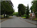
Bridgnorth Road at Compton, Wolverhampton
The minor road off to the right is Alpine Way. Compton Hospice is behind the trees to the left.
Image: © Roger D Kidd
Taken: 11 May 2014
0.17 miles
3
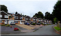
Housing in Alpine Way, Compton, Wolverhampton
Alpine Way is a quiet cul-de-sac on the north side of the A454 Bridgnorth Road.
Image: © Roger D Kidd
Taken: 25 Aug 2017
0.17 miles
4
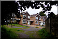
Housing in Alpine Way, Compton, Wolverhampton
Alpine Way is a quiet cul-de-sac on the north side of the A454 Bridgnorth Road.
It is seen here from the track to the railway walk.
Image: © Roger D Kidd
Taken: 25 Aug 2017
0.18 miles
5
Linden Lea Junction
The view of the junction with Compton Road West in Finchfield, Wolverhampton.
Image: © Gordon Griffiths
Taken: 12 Jun 2020
0.18 miles
6
Nature Reserve View
The view in the Smestow Valley Local nature reserve near Tettenhall.
Image: © Gordon Griffiths
Taken: 21 Mar 2022
0.19 miles
7
Smestow Valley
The view of the path under the South Staffordshire Railway Walk from Alpine Way Wolverhampton into the Nature Reserve.
Image: © Gordon Griffiths
Taken: 15 May 2015
0.20 miles
8
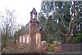
Redundant Church at Finchfield
The Church, in Oak Hill, was dedicated to St. Thomas. Now a listed building, it was closed and put up for sale in 2000 but no buyer has, as yet, been found
Image: © Geoff Pick
Taken: 25 Feb 2006
0.20 miles
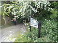
9
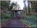
Bridge Path
The view of the path under the South Staffordshire Railway Walk from Alpine Way Wolverhampton into the Smestow Valley Nature Reserve.
Image: © Gordon Griffiths
Taken: 9 Jan 2023
0.20 miles
10
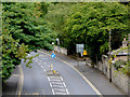
Bridgnorth Road in Compton, Wolverhampton
The A454 Bridgnorth Road, looking east towards Wolverhampton city centre, from the former railway bridge.
Image: © Roger D Kidd
Taken: 25 Aug 2017
0.20 miles