IMAGES TAKEN NEAR TO
Compton Road West, WOLVERHAMPTON, WV3 9DU
Introduction
This page details the photographs taken nearby to Compton Road West, WV3 9DU by members of the Geograph project.
The Geograph project started in 2005 with the aim of publishing, organising and preserving representative images for every square kilometre of Great Britain, Ireland and the Isle of Man.

There are currently over 7.5m images from over14,400 individuals and you can help contribute to the project by visiting https://www.geograph.org.uk
Image Map
Images are licensed for reuse under creativecommons.org/licenses/by-sa/2.0
Notes
- Clicking on the map will re-center to the selected point.
- The higher the marker number, the further away the image location is from the centre of the postcode.
Image Listing (10 Images Found)
Images are licensed for reuse under creativecommons.org/licenses/by-sa/2.0
Image
Details
Distance
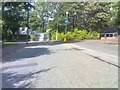
1
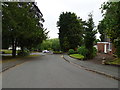
Linden Lea Junction
The view of the junction with Compton Road West in Finchfield, Wolverhampton.
Image: © Gordon Griffiths
Taken: 12 Jun 2020
0.08 miles
2
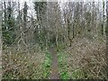
Valley Path
The view on the Smestow Valley Local nature reserve near Tettenhall.
Image: © Gordon Griffiths
Taken: 21 Mar 2022
0.16 miles
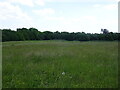
4
Smestow Valley Local Nature Reserve View
The view of the Valley Park nature reserve off Compton Hill Drive in Compton, Wolverhampton.
Image: © Gordon Griffiths
Taken: 21 Mar 2022
0.19 miles
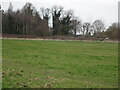
5
Reserve View
The view in Compton over the Smestow Valley Local Nature Reserve in Wolverhampton.
Image: © Gordon Griffiths
Taken: 15 Jun 2023
0.19 miles
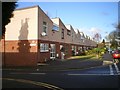
6
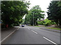
Compton Road West
The view in Finchfield, Wolverhampton.
Image: © Gordon Griffiths
Taken: 12 Jun 2020
0.19 miles
7
Nature Reserve View
The view in the Smestow Valley Local nature reserve near Tettenhall.
Image: © Gordon Griffiths
Taken: 21 Mar 2022
0.20 miles
8
Richmond Road View
The view to Compton Road in Merridale, Wolverhampton.
Image: © Gordon Griffiths
Taken: 23 Sep 2018
0.23 miles
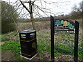
9
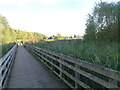
Boardwalk View
The view from Valley Park nature reserve towards the St Edmunds School in Tettenhall.
Image: © Gordon Griffiths
Taken: 15 Oct 2020
0.23 miles
10
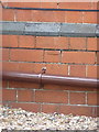
OS benchmark - Merridale, 157 Compton Road
An OS cutmark on the NW corner of number 157, Compton Road; originally levelled at 113.989m above Ordnance Datum Newlyn.
Image: © Richard Law
Taken: 3 Aug 2015
0.25 miles