IMAGES TAKEN NEAR TO
White Oak Drive, WOLVERHAMPTON, WV3 9AW
Introduction
This page details the photographs taken nearby to White Oak Drive, WV3 9AW by members of the Geograph project.
The Geograph project started in 2005 with the aim of publishing, organising and preserving representative images for every square kilometre of Great Britain, Ireland and the Isle of Man.

There are currently over 7.5m images from over14,400 individuals and you can help contribute to the project by visiting https://www.geograph.org.uk
Image Map (48 Images)

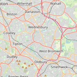


Leaflet Map data © OpenStreetMap
Images are licensed for reuse under creativecommons.org/licenses/by-sa/2.0
Notes
- Clicking on the map will re-center to the selected point.
- The higher the marker number, the further away the image location is from the centre of the postcode.
Image Listing (48 Images Found)
Images are licensed for reuse under creativecommons.org/licenses/by-sa/2.0
Image
Details
Distance
1
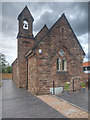
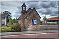
The Windmill Community Church
Originally built in 1875 as a mission church to Christ Church, Tettenhall Wood (http://www.historywebsite.co.uk/listed/localist/stthomas.htm Wolverhampton's Locally Listed Churches). It fell out of use in the latter half of the twentieth century, being put up for sale by auction in 2000. See https://windmillcommunitychurch.co.uk/restoring-st-thomas-church/ for details of the restoration.
Image: © David Dixon
Taken: 26 Jul 2019
0.09 miles
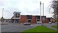
3
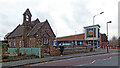
Old church and modern supermarket in Finchfield, Wolverhampton
Looking north near the junction of Oak Hill, Finchfield Hill and Finchfield Road West. The Lidl store opened circa 2009 after many years of delay in planning, then a further delay because they were ignoring height restrictions on their approved development plans.
The thriving Windmill Community Church https://www.windmillcommunitychurch.org/ was formerly the Church of St Thomas, built in 1875, and closed in 1997. Considerable restoration work was required before it reopened circa 2020-2021.
Image: © Roger Kidd
Taken: 22 Nov 2022
0.09 miles
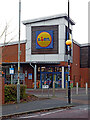
4
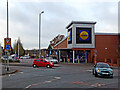
Lidl supermarket in Finchfield, Wolverhampton
The Lidl supermarket car park is accessed directly from the roundabout/junction
of three roads: Finchfield Hill, Finchfield Road West and Oak Hill.
Image: © Roger Kidd
Taken: 22 Nov 2022
0.09 miles
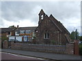
5
Windmill Community Church, Oak Hill
Originally built in 1875 as a mission church to Christ Church, Tettenhall Wood (http://www.historywebsite.co.uk/listed/localist/stthomas.htm Wolverhampton's Locally Listed Churches). It fell out of use in the latter half of the twentieth century, being put up for sale by auction in 2000. See https://windmillcommunitychurch.co.uk/restoring-st-thomas-church/ for details of the restoration.
Image: © David Dixon
Taken: 26 Jul 2019
0.09 miles
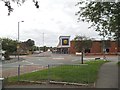
6
Lidl supermarket in Finchfield, Wolverhampton
Looking north-west from Finchfield Road West. Finchfield Hill leads towards Compton, off to the right.
Image: © Roger Kidd
Taken: 22 Nov 2022
0.10 miles
7
Lidl in Finchfield, Wolverhampton
Seen from the top of Oak Hill.
Image: © Roger Kidd
Taken: 22 Nov 2022
0.10 miles
8
Finchfield Supermarket
The view of Lidl at the top of Finchfield Hill, Wolverhampton.
Image: © Gordon Griffiths
Taken: 24 Aug 2013
0.10 miles
9

Old church on Oak Hill, Finchfield
Seven years on from Image, it appears that this closed church has still to find a new purpose. The adjacent Lidl supermarket appeared to be very new, though it appears that Lidl were attempting to obtain planning permission for it over six years ago (see Image). Things appear to happen slowly in Finchfield.
Image: © Richard Vince
Taken: 6 Jun 2013
0.10 miles
10
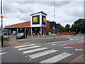
Crossing at Lidl
Pedestrian crossing on Oak Hill, outside the Lidl supermarket.
Image: © David Dixon
Taken: 26 Jul 2019
0.10 miles