IMAGES TAKEN NEAR TO
Brantley Avenue, WOLVERHAMPTON, WV3 9AR
Introduction
This page details the photographs taken nearby to Brantley Avenue, WV3 9AR by members of the Geograph project.
The Geograph project started in 2005 with the aim of publishing, organising and preserving representative images for every square kilometre of Great Britain, Ireland and the Isle of Man.

There are currently over 7.5m images from over14,400 individuals and you can help contribute to the project by visiting https://www.geograph.org.uk
Image Map
Images are licensed for reuse under creativecommons.org/licenses/by-sa/2.0
Notes
- Clicking on the map will re-center to the selected point.
- The higher the marker number, the further away the image location is from the centre of the postcode.
Image Listing (71 Images Found)
Images are licensed for reuse under creativecommons.org/licenses/by-sa/2.0
Image
Details
Distance
1
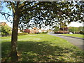
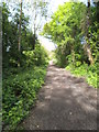
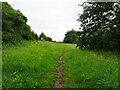
Brantley Avenue View
The view from the South Staffordshire Railway Walk at Finchfield, Wolverhampton.
Image: © Gordon Griffiths
Taken: 15 May 2015
0.01 miles
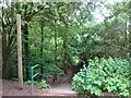
2
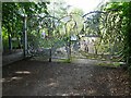
Nursery Gates View
The view from the Railway walk Finchfield, Wolverhampton.
Image: © Gordon Griffiths
Taken: 23 Sep 2021
0.06 miles
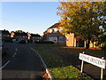
3
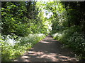
Railway walk passing Finchfield
Most of the trackbed of the relatively short lived (1925-65) railway between Oxley and Pensnett via Wombourne has been converted into a footpath. Part of it has been designated a linear park, and provides a pleasantly quiet route through the western suburbs of Wolverhampton. This section passes behind the houses on Westacre Crescent in Finchfield.
Image: © Richard Vince
Taken: 28 May 2016
0.07 miles
4
Path Scene
The view in Castlecroft of the South Staffordshire Railway Walk in Wolverhampton.
Image: © Gordon Griffiths
Taken: 23 Nov 2020
0.08 miles
5
Railway Path Scene
The view on the South Staffordshire Railway Walk at Castlecroft.
Image: © Gordon Griffiths
Taken: 15 May 2015
0.11 miles
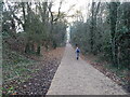
6
Path Steps
The view near the Compton Halt on the South Staffordshire Railway Walk in Wolverhampton.
Image: © Gordon Griffiths
Taken: 9 Jun 2022
0.14 miles
10
Reserve Path
The view in Smestow Valley Local Nature Reserve.
Image: © Gordon Griffiths
Taken: 9 Jun 2022
0.17 miles