IMAGES TAKEN NEAR TO
Uplands Avenue, WOLVERHAMPTON, WV3 8AA
Introduction
This page details the photographs taken nearby to Uplands Avenue, WV3 8AA by members of the Geograph project.
The Geograph project started in 2005 with the aim of publishing, organising and preserving representative images for every square kilometre of Great Britain, Ireland and the Isle of Man.

There are currently over 7.5m images from over14,400 individuals and you can help contribute to the project by visiting https://www.geograph.org.uk
Image Map
Images are licensed for reuse under creativecommons.org/licenses/by-sa/2.0
Notes
- Clicking on the map will re-center to the selected point.
- The higher the marker number, the further away the image location is from the centre of the postcode.
Image Listing (80 Images Found)
Images are licensed for reuse under creativecommons.org/licenses/by-sa/2.0
Image
Details
Distance
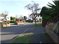
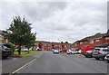
1

Uplands Avenue View
The view in Finchfield, Wolverhampton.
Image: © Gordon Griffiths
Taken: 3 Feb 2019
0.02 miles
2

Uplands Avenue
The view in Finchfield, Wolverhampton.
Image: © Gordon Griffiths
Taken: 3 Feb 2019
0.05 miles
3
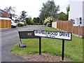
Bramblewood Drive
The view from Broad Lane in Bradmore, Wolverhampton.
Image: © Gordon Griffiths
Taken: 4 Jun 2017
0.06 miles
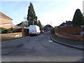
4
Willow Road Bend
The view along the street in Finchfield, Wolverhampton.
Image: © Gordon Griffiths
Taken: 3 Feb 2019
0.06 miles
5
Uplands Avenue
The view from Broad Lane in Bradmore, Wolverhampton.
Image: © Gordon Griffiths
Taken: 4 Jun 2017
0.07 miles
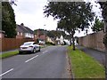
6
Alderton Drive
The view in Bradmore, Wolverhampton.
Image: © Gordon Griffiths
Taken: 14 Jul 2019
0.08 miles
7
Alderton Drive View
The view in Bradmore, Wolverhampton.
Image: © Gordon Griffiths
Taken: 14 Jul 2019
0.08 miles
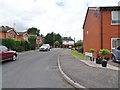
8
Uplands Drive
The view from Uplands Avenue in Finchfield, Wolverhampton.
Image: © Gordon Griffiths
Taken: 3 Feb 2019
0.08 miles
9
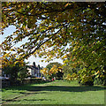
Bantock Park at Bradmore, Wolverhampton
Bantock Park occupies the triangle formed by Broad Lane (to the left of the hedge here), Finchfield Road and Bradmore Road. Bantock House Museum is towards the eastern corner of the park.
The city council's website informs us that the park is approximately 16 hectares (39.53 acres) in area. The west of the park is mostly open space, which still retains its 'rural' character, with gently undulating ground, hedgerows and a variety of trees with a nature trail. The eastern side of the park changes near Bantock House, becoming more formal. This area consists of a series of recently restored gardens, reminiscent of the detail emerging around the late nineteenth/twentieth century.
Image: © Roger D Kidd
Taken: 20 Oct 2010
0.10 miles
10
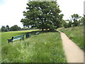
Bantock Park Benchs
The view in Bantock Park off Broad Lane, Wolverhampton.
Image: © Gordon Griffiths
Taken: 29 Jun 2013
0.10 miles