IMAGES TAKEN NEAR TO
Coalway Road, WOLVERHAMPTON, WV3 7NB
Introduction
This page details the photographs taken nearby to Coalway Road, WV3 7NB by members of the Geograph project.
The Geograph project started in 2005 with the aim of publishing, organising and preserving representative images for every square kilometre of Great Britain, Ireland and the Isle of Man.

There are currently over 7.5m images from over14,400 individuals and you can help contribute to the project by visiting https://www.geograph.org.uk
Image Map
Images are licensed for reuse under creativecommons.org/licenses/by-sa/2.0
Notes
- Clicking on the map will re-center to the selected point.
- The higher the marker number, the further away the image location is from the centre of the postcode.
Image Listing (69 Images Found)
Images are licensed for reuse under creativecommons.org/licenses/by-sa/2.0
Image
Details
Distance
1
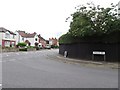
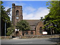
Windsor Avenue Junction
The view of the junction with Coalway Road in Penn, Wolverhampton.
Image: © Gordon Griffiths
Taken: 13 Jul 2019
0.04 miles
3
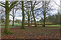
Bradmore Recreation Ground in Penn Fields, Wolverhampton
Looking east towards Church Road and the tennis (and other sports) courts and the bowling green. The children's playground is off to the left. http://wikimapia.org/37679682/Bradmore-Recreation-Ground
Image: © Roger D Kidd
Taken: 25 Dec 2024
0.09 miles
4
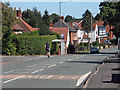
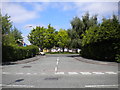
Church Road Scene
The view by St Philip's Church in Pennfields, Wolverhampton.
Image: © Gordon Griffiths
Taken: 8 Oct 2023
0.09 miles
5
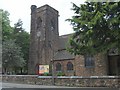
St Philip's Church
A Church on Church Road, Pennfields.
Image: © Gordon Griffiths
Taken: 11 May 2007
0.09 miles
6
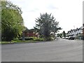
Myrtle Grove, Penn
A short residential cul de sac off Coalway Road, which expands to surround a small green. For some reason its name always fascinated me when I was a child, so I thought I should geograph it.
Image: © Richard Vince
Taken: 6 Jun 2013
0.09 miles
8
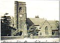
St. Phillips Church Pennfields
Photo from c1930 of the church in Church Road Pennfields
Image: © Ethel Tiller 1885-1946
Taken: Unknown
0.10 miles
9
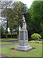
Penn Fields Cenotaph
A monument to the local men killed in the 1st World War, in Church Road.
Image: © Gordon Griffiths
Taken: 11 May 2007
0.10 miles
10
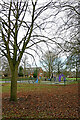
Play area in Bradmore Recreation Ground, Wolverhampton
Looking north-east towards the Hazel Road entrance.
Image: © Roger D Kidd
Taken: 25 Dec 2024
0.10 miles