IMAGES TAKEN NEAR TO
Coalway Road, WOLVERHAMPTON, WV3 7NA
Introduction
This page details the photographs taken nearby to Coalway Road, WV3 7NA by members of the Geograph project.
The Geograph project started in 2005 with the aim of publishing, organising and preserving representative images for every square kilometre of Great Britain, Ireland and the Isle of Man.

There are currently over 7.5m images from over14,400 individuals and you can help contribute to the project by visiting https://www.geograph.org.uk
Image Map
Images are licensed for reuse under creativecommons.org/licenses/by-sa/2.0
Notes
- Clicking on the map will re-center to the selected point.
- The higher the marker number, the further away the image location is from the centre of the postcode.
Image Listing (68 Images Found)
Images are licensed for reuse under creativecommons.org/licenses/by-sa/2.0
Image
Details
Distance
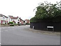
1
Church Road Scene
The view by St Philip's Church in Pennfields, Wolverhampton.
Image: © Gordon Griffiths
Taken: 8 Oct 2023
0.06 miles
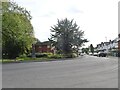
2
Windsor Avenue Junction
The view of the junction with Coalway Road in Penn, Wolverhampton.
Image: © Gordon Griffiths
Taken: 13 Jul 2019
0.08 miles
3
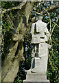
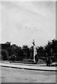
War memorial in Penn Fields, Wolverhampton
In Church Road, opposite the entrance to St Philip's Church, is a small memorial garden originally laid out for the first world war. The inscription on it reads: "This Statue is erected as a lasting tribute to the men of Penn Fields Bradmore and Merry Hill who served in His Majesty's Forces during the Great War, 1914-1919. The names of those who paid the supreme sacrifice are engraved hereon."
This, and further information can be seen here: http://www.localhistory.scit.wlv.ac.uk/listed/stphillipsch.htm
Image: © Roger D Kidd
Taken: 20 Apr 2011
0.09 miles
4
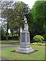
Penn Fields Cenotaph
A monument to the local men killed in the 1st World War, in Church Road.
Image: © Gordon Griffiths
Taken: 11 May 2007
0.09 miles
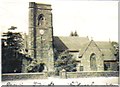
5
St. Philip's Church War Memorial garden
Photo c1930 War Memorial opposite St. Philip's Church in Church Road, Statue has a complete rifle!
Image: © LouLou Whitehouse 1905-1965
Taken: 1 Jan 1930
0.09 miles
6
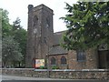
St Philip's Church
A Church on Church Road, Pennfields.
Image: © Gordon Griffiths
Taken: 11 May 2007
0.10 miles
7
St. Phillips Church Pennfields
Photo from c1930 of the church in Church Road Pennfields
Image: © Ethel Tiller 1885-1946
Taken: Unknown
0.10 miles
9
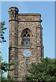
St Philip's Church tower in Penn Fields, Wolverhampton
When this Grade II listed church was built in 1858-1859 it really was in the middle of the fields, and it was many decades before housing development began to surround it. Visitors will have a shock when they enter through the main door; the whole interior of the church was divided into two floors in 1997. The ground floor is for community use, while the upper floor is now the church area for worship. See here http://britishlistedbuildings.co.uk/en-378356-church-of-st-philip-wolverhampton for a description of what is no longer there.
Image: © Roger D Kidd
Taken: 20 Apr 2011
0.10 miles
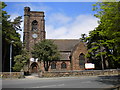
10
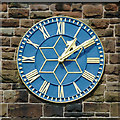
St Philip's Church clock in Penn Fields, Wolverhampton
When this Grade II listed church was built in 1858-1859 it really was in the middle of the fields, and it was many decades before housing development began to surround it. Visitors will have a shock when they enter through the main door; the whole interior of the church was divided into two floors in 1997. The ground floor is for community use, while the upper floor is now the church area for worship. See here http://britishlistedbuildings.co.uk/en-378356-church-of-st-philip-wolverhampton for a description of what is no longer there.
See alsoImage
Image: © Roger D Kidd
Taken: 20 Apr 2011
0.10 miles