IMAGES TAKEN NEAR TO
Bromford Rise, WOLVERHAMPTON, WV3 0ES
Introduction
This page details the photographs taken nearby to Bromford Rise, WV3 0ES by members of the Geograph project.
The Geograph project started in 2005 with the aim of publishing, organising and preserving representative images for every square kilometre of Great Britain, Ireland and the Isle of Man.

There are currently over 7.5m images from over14,400 individuals and you can help contribute to the project by visiting https://www.geograph.org.uk
Image Map
Images are licensed for reuse under creativecommons.org/licenses/by-sa/2.0
Notes
- Clicking on the map will re-center to the selected point.
- The higher the marker number, the further away the image location is from the centre of the postcode.
Image Listing (257 Images Found)
Images are licensed for reuse under creativecommons.org/licenses/by-sa/2.0
Image
Details
Distance
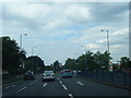
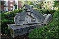
2
Penn Road Crossing
The view along the A449 dual carriageway in Wolverhampton.
Image: © Gordon Griffiths
Taken: 1 Feb 2018
0.04 miles
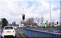
3
Penn Road (A449) - Oaklands Road traffic lights
Image: © J Whatley
Taken: 6 Sep 2010
0.04 miles
4
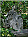
Concrete AJS motorcycle sculpture by Penn Road, Wolverhampton
This is now partly hidden in bushes by a footpath linking Penn Road with the Tesco (formerly Waitrose, formerly Morrison's, originally Safeway) supermarket. It was installed in the early 1980s when Safeway opened the new store.
A. J. Stevens & Company (1914) Limited was one of the most important motorcycle manufacturers in the Midlands. The company was formed in 1914 and built a new works on the site now occupied by the supermarket. The works eventually covered about 230,000 sq ft and the company produced up to 25,000 machines a year in its heyday. Its motorcycles were very successful in competitions and the Isle of Man T.T., and gained a reputation for quality. The company sadly closed in 1931. (Information from here: http://www.historywebsite.co.uk/plaques/PennRoad.htm )
Image: © Roger Kidd
Taken: 15 Sep 2021
0.04 miles
5
Concrete AJS motorcycle sculpture by Penn Road, Wolverhampton
This is now partly hidden in bushes by a footpath linking Penn Road with the Tesco (formerly Waitrose, formerly Morrison's, originally Safeway) supermarket. It was installed in the early 1980s when Safeway opened the new store.
A. J. Stevens & Company (1914) Limited was one of the most important motorcycle manufacturers in the Midlands. The company was formed in 1914 and built a new works on the site now occupied by the supermarket. The works eventually covered about 230,000 sq ft and the company produced up to 25,000 machines a year in its heyday. Its motorcycles were very successful in competitions and the Isle of Man T.T., and gained a reputation for quality. The company sadly closed in 1931. (Information from here: http://www.historywebsite.co.uk/plaques/PennRoad.htm )
Image: © Roger Kidd
Taken: 15 Sep 2021
0.04 miles
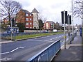
6
Penn Road Lights
The view of the junction with Marston Road in Wolverhampton.
Image: © Gordon Griffiths
Taken: 1 Feb 2018
0.04 miles
7
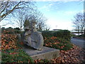
The Lone Rider
The view of the Concrete AJS motorcycle sculpture by the Penn Road, Wolverhampton.
This is now partly hidden in bushes on a footpath linking Penn Road with the Tesco (formerly Waitrose, formerly Morrison's, originally Safeway) supermarket. It was installed in the early 1980s when Safeway opened the new store.
The view in August 2005 Image
Image: © Gordon Griffiths
Taken: 2 Dec 2021
0.04 miles
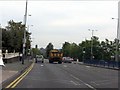
8
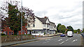
A449 Penn road in Blakenhall, Wolverhampton
By the Goldthorn Hotel, looking north-north-east towards Wolverhampton city centre.
Permission has now been granted to demolish the Goldthorn Hotel (recently called Quality Hotel, then Mercure Goldthorn Hotel; sold by them to Talash Hotels in 2017). It is to be replaced by another Lidl supermarket, less than two hundred metres from the entrance to a larger Tesco supermarket. The original building (before multiple extensions) dates from c1894 was called The Pines; a private residence.
There is a lot of local discontent!
https://www.expressandstar.com/news/local-hubs/wolverhampton/2021/05/03/lidl-submits-plans-for-new-store-at-old-hotel-site/
https://www.expressandstar.com/news/local-hubs/wolverhampton/2022/05/25/wolverhampton-hotel-to-be-demolished-and-replaced-with-lidl-supermarket/
https://www.birminghammail.co.uk/black-country/glitzy-hotel-famous-stars-once-24058884
Image: © Roger Kidd
Taken: 26 Aug 2022
0.05 miles
9
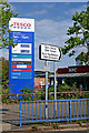
Tesco fuel and temple sign in Wolverhampton
The supermarket by Penn Road/Marston Road was built for Safeway in the early 1980s(?), and was taken over by Morrison's in February 2004. Within a year or so Morrison's were forced to sell it on to Waitrose because of "competition regulation" laws. In September 2020 it was announced that the store would be closing on 31 December, and would be operated by Tesco from early 2021.
Tesco re-opened the doors on 30 June 2021.
Waitrose had a very clear and easy to read fuel price board. Tesco decided not to. The prices are 129·9/130·9 for petrol/diesel. I passed by on a bus on 16 September, and still could not see the price. Whoever designed this is a fool, more interested in brand colour co-ordination than clear signage.
Image]
Image: © Roger Kidd
Taken: 15 Sep 2021
0.05 miles
10
Bromford Road
The view in Merridale, Wolverhampton.
Image: © Gordon Griffiths
Taken: 5 May 2018
0.05 miles