IMAGES TAKEN NEAR TO
Penn Road, WOLVERHAMPTON, WV3 0EE
Introduction
This page details the photographs taken nearby to Penn Road, WV3 0EE by members of the Geograph project.
The Geograph project started in 2005 with the aim of publishing, organising and preserving representative images for every square kilometre of Great Britain, Ireland and the Isle of Man.

There are currently over 7.5m images from over14,400 individuals and you can help contribute to the project by visiting https://www.geograph.org.uk
Image Map
Images are licensed for reuse under creativecommons.org/licenses/by-sa/2.0
Notes
- Clicking on the map will re-center to the selected point.
- The higher the marker number, the further away the image location is from the centre of the postcode.
Image Listing (189 Images Found)
Images are licensed for reuse under creativecommons.org/licenses/by-sa/2.0
Image
Details
Distance
1
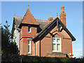
Detached house (detail) on Penn Road, Wolverhampton
This substantial detached house, in need of some maintenance, is one of many grand residences from the early 20th century, found along the A449 Penn Road out of Wolverhampton.
Image: © Roger D Kidd
Taken: 25 Feb 2012
0.00 miles
2
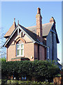
Detached house on Penn Road, Wolverhampton
This substantial detached house, in need of some maintenance, is one of many grand residences from the early 20th century, found along the A449 Penn Road out of Wolverhampton.
Image: © Roger D Kidd
Taken: 25 Feb 2012
0.00 miles
3
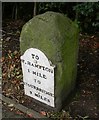
Old Milestone by the A449, Penn Road, Blakenhall
Metal plate attached to stone post by the A449, in parish of WOLVERHAMPTON (WOLVERHAMPTON District), Penn Road, near junction with Goldthorn Road, behind pavement in hedge, opposite Royal Wolverhampton School, on East side of road, next to bus stop. Wolverhampton iron plate, erected by the Streetway & Wordsley Green turnpike trust in the 19th century.
Inscription reads:-
TO
W.HAMPTON
1 MILE
TO
STOURBRIDGE
9
MILES
Wolverhampton and Walsall HER.
HER Number: 13632 https://www.heritagegateway.org.uk/Gateway/Results_Single.aspx?uid=MBL5533&resourceID=1025
Milestone Society National ID: ST_WVSB01
Image: © Mike Faherty
Taken: 12 Oct 2006
0.01 miles
4
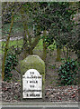
Milestone on Penn Road, Wolverhampton
This is on the A449 which goes from Stafford to Kidderminster, then eventually Newport in Gwent. On the opposite side of the road is a Victorian wall post box.
Image]
Image: © Roger D Kidd
Taken: 27 Feb 2009
0.02 miles
5
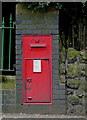
Victorian Post Box on Penn Road, Wolverhampton
This rather scrappily painted box is on the A449 which goes from Stafford to Kidderminster, then eventually Newport in Gwent. Collections are at 5:30pm Mondays to Fridays, and 12:45pm on Saturdays. On the opposite side of the road is an old milestone stating that it is one mile to Wolverhampton, and nine miles to Stourbridge. Either of these artefacts could be lost if and when the road is widened.
Image]
Image: © Roger D Kidd
Taken: 27 Feb 2009
0.02 miles
6
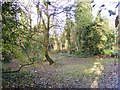
Penn Road Coppice
The view by the Royal School in Blakenhall, Wolverhampton.
Image: © Gordon Griffiths
Taken: 5 Nov 2017
0.03 miles
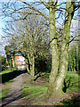
7
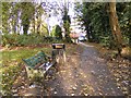
Penn Road Footpath
The view of the footpath from the Royal School in Blakenhall, Wolverhampton.
Image: © Gordon Griffiths
Taken: 5 Nov 2017
0.03 miles
8

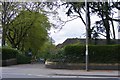
Claremont Road
The view from the Penn Road in Blakenhall, Wolverhampton.
Image: © Gordon Griffiths
Taken: 5 Nov 2017
0.03 miles
9
School Drive View
The view across the Penn Road to the Royal School in Blakenhall, Wolverhampton.
Image: © Gordon Griffiths
Taken: 1 May 2018
0.03 miles
10
Footpath to Penn Road, Wolverhampton
The large area in front of the restored Goldthorn Terrace has been allowed to grow into pleasant landscaped mature woodland.
Image: © Roger D Kidd
Taken: 25 Feb 2012
0.03 miles