IMAGES TAKEN NEAR TO
Oaklands Road, WOLVERHAMPTON, WV3 0DS
Introduction
This page details the photographs taken nearby to Oaklands Road, WV3 0DS by members of the Geograph project.
The Geograph project started in 2005 with the aim of publishing, organising and preserving representative images for every square kilometre of Great Britain, Ireland and the Isle of Man.

There are currently over 7.5m images from over14,400 individuals and you can help contribute to the project by visiting https://www.geograph.org.uk
Image Map
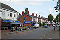
Images are licensed for reuse under creativecommons.org/licenses/by-sa/2.0
Notes
- Clicking on the map will re-center to the selected point.
- The higher the marker number, the further away the image location is from the centre of the postcode.
Image Listing (247 Images Found)
Images are licensed for reuse under creativecommons.org/licenses/by-sa/2.0
Image
Details
Distance
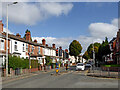
1
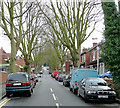
Lonsdale Road, Wolverhampton
Substantial semi-detached houses built in the early 20th century with a fine avenue of plane trees. The A449 Penn Road crosses at the top of the slope.
Image: © Roger D Kidd
Taken: 8 Dec 2009
0.01 miles
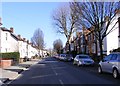
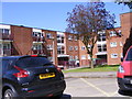
2
Oaklands Road View
The view in Wolverhampton.
Image: © Gordon Griffiths
Taken: 25 Feb 2018
0.02 miles
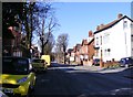
3
Oaklands Road
The view in Merridale, Wolverhampton.
Image: © Gordon Griffiths
Taken: 3 Feb 2018
0.03 miles
4
Lea Road
The view in Wolverhampton.
Image: © Gordon Griffiths
Taken: 25 Feb 2018
0.06 miles
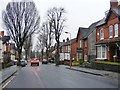
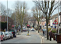
5
Lea Road near Graiseley in Wolverhampton
Looking north-east towards the A449 Penn Road, and Wolverhampton city centre, from the junction with Oaklands Road.
Image: © Roger Kidd
Taken: 10 Oct 2021
0.06 miles
6
Bromford Road
The view in Merridale, Wolverhampton.
Image: © Gordon Griffiths
Taken: 5 May 2018
0.07 miles
7
Lea Road in Penn Fields, Wolverhampton
This is a telephoto assisted image looking away from the city, towards the (recently installed) traffic lights where Owen Road leads off to the right, and Oaklands Road goes left to the A449 Penn Road. Clearly, Thursday is "bins" day!
Image: © Roger D Kidd
Taken: 21 Feb 2013
0.07 miles
8

Lea Road Scene
The view in Merridale, Wolverhampton.
Image: © Gordon Griffiths
Taken: 5 May 2018
0.07 miles
9
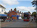
Lea Road near Graiseley in Wolverhampton
Looking north-east towards the junction with Owen Road and Oaklands Road; also the A449 Penn Road and Wolverhampton city centre.
Route No 2 is now a cross city service between Bushbury and Warstones.
The National Express bus (No 5409) dating from 2011 is an Alexander Dennis Enviro 400 Hybrid, apparently called Hayley!
Image: © Roger Kidd
Taken: 10 Oct 2021
0.07 miles
10
Lea Road near Graiseley in Wolverhampton
Looking north-east towards the junction with Owen Road and Oaklands Road; also the A449 Penn Road and Wolverhampton city centre.
Image: © Roger Kidd
Taken: 10 Oct 2021
0.07 miles