IMAGES TAKEN NEAR TO
Upper Villiers Street, WOLVERHAMPTON, WV2 4NU
Introduction
This page details the photographs taken nearby to Upper Villiers Street, WV2 4NU by members of the Geograph project.
The Geograph project started in 2005 with the aim of publishing, organising and preserving representative images for every square kilometre of Great Britain, Ireland and the Isle of Man.

There are currently over 7.5m images from over14,400 individuals and you can help contribute to the project by visiting https://www.geograph.org.uk
Image Map
Images are licensed for reuse under creativecommons.org/licenses/by-sa/2.0
Notes
- Clicking on the map will re-center to the selected point.
- The higher the marker number, the further away the image location is from the centre of the postcode.
Image Listing (255 Images Found)
Images are licensed for reuse under creativecommons.org/licenses/by-sa/2.0
Image
Details
Distance
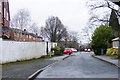
1
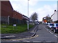
Cyprus Street
The view in Blakenhall Wolverhampton.
Image: © Gordon Griffiths
Taken: 31 Jan 2013
0.03 miles
2
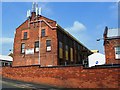
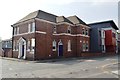
Moorfields Works - Trimming Shop
The Trimming Shop was built in the 1915-1918 Great War expansion of the Sunbeam Motor Company factory.
The building was erected for the assembly of seaplanes using designs by Shorts and other manufacturers. The factory produced a range of engines designed by Louis Coatelen. During the war the factory delivered over 600 aircraft.
Image: © John M
Taken: 27 May 2016
0.05 miles
3
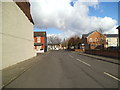
Fowler Street
The view in Blakenhall Wolverhampton, looking towards St Luke's Church.
Image: © Gordon Griffiths
Taken: 11 Mar 2013
0.05 miles
4
Moorfields Works - Repair Department
The Repair Department was built in the 1915-1918 Great War expansion of the Sunbeam Motor Company factory.
Image: © John M
Taken: 27 May 2016
0.06 miles
5
Asha House - Upper Villiers Street
The Villiers Arms PH was built in the late 1920s adjacent to the Sumbeam Motor Company's Millfields Works. The pub closed in the 1970s and was converted into apartments. The property was recently renovated by Midland Heart with a modern extension.
Image: © John M
Taken: 27 May 2016
0.06 miles
6
Moorfields Works - Canteen
The Canteen was built in the 1915-1918 Great War expansion of the Sunbeam Motor Company factory.
Image: © John M
Taken: 27 May 2016
0.07 miles
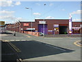
7
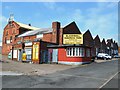
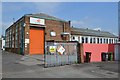
Blakenhall Business Park
The view off Upper Villiers Street, Wolverhampton.
Image: © Gordon Griffiths
Taken: 18 Jul 2012
0.07 miles
8
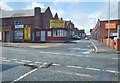
Chetwynd Road Junction
The view from Upper Villiers Street in Blakenhall, Wolverhampton.
Image: © Gordon Griffiths
Taken: 20 Mar 2013
0.07 miles
9
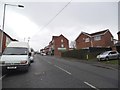
Bromwynd Close
The view from Chetwynd Road in Blakenhall, Wolverhampton.
Image: © Gordon Griffiths
Taken: 27 Jan 2018
0.07 miles
10
Blakenhall, Bizspace Business Park
On Upper Villiers Street, junction Moorfield Road http://www.bizspace.co.uk/property51.aspx
Image: © Mike Faherty
Taken: 26 Apr 2009
0.08 miles