IMAGES TAKEN NEAR TO
Pool Street, WOLVERHAMPTON, WV2 4NE
Introduction
This page details the photographs taken nearby to Pool Street, WV2 4NE by members of the Geograph project.
The Geograph project started in 2005 with the aim of publishing, organising and preserving representative images for every square kilometre of Great Britain, Ireland and the Isle of Man.

There are currently over 7.5m images from over14,400 individuals and you can help contribute to the project by visiting https://www.geograph.org.uk
Image Map
Images are licensed for reuse under creativecommons.org/licenses/by-sa/2.0
Notes
- Clicking on the map will re-center to the selected point.
- The higher the marker number, the further away the image location is from the centre of the postcode.
Image Listing (280 Images Found)
Images are licensed for reuse under creativecommons.org/licenses/by-sa/2.0
Image
Details
Distance
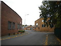
1
Graiseley Youth Centre
The Support Centre is off Stanford Road, Wolverhampton in the old Graiseley Primary School.
Image: © Gordon Griffiths
Taken: 18 Jul 2012
0.03 miles
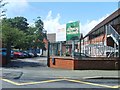
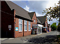
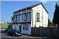
2
Graiseley Strengthening Families Hub, Pool Street
I remember this building as the Recreation Centre, which contained a gym (in which I voted in my first general election). The building visible beyond it on the left was Wolverhampton Music School, past which one continued to reach Graiseley Nursery.
Image: © Richard Vince
Taken: 24 Sep 2017
0.03 miles
3
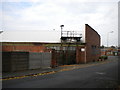
S J & E Fellows, Pool Street, Graiseley
One of a few businesses hereabouts that has been here for as long as I can remember. The platform attached to the factory roof formerly supported a huge extractor, which fascinated me as a child when I played in the park over the road (out of frame to the right).
Image: © Richard Vince
Taken: 24 Sep 2017
0.04 miles
4
The Queens Arms
A pub on Graiseley Row, currently closed and awaiting a new lease of life. For more information, see Image
Image: © Richard Law
Taken: 12 May 2009
0.04 miles
5
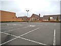
Car Park View
The view from Waitrose car park Blakenhall Wolverhampton towards the Graiseley School.
Image: © Gordon Griffiths
Taken: 6 Jan 2013
0.04 miles
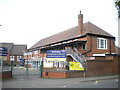
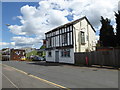
6
Graiseley Primary and Music schools, Wolverhampton
These buildings, dating from 1910, accommodate Graiseley Primary School and the Wolverhampton Music Service, formerly Graiseley Music School.
Image: © Roger D Kidd
Taken: 1 May 2017
0.05 miles
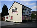
7
The Kasbar in Graiseley Row, Wolverhampton
This was formerly the well liked back street Queen's Arms, a Burtonwood public house serving well kept real ale. Partly painted in shades of pink and yellow, it then became a gay club/bar for a while before being closed down. Now it is an Indian food restaurant and bar with very encouraging reviews on Tripadvisor (2017).
Image: © Roger D Kidd
Taken: 7 Jun 2017
0.05 miles
8
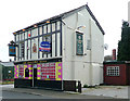
The Queen's Arms, Wolverhampton
This pub is hidden away in an area of small and medium sized industrial businesses in Graiseley Row, near the A449 Penn Road. In the 1970s and 1980s it was a favoured venue for the real ale enthusiasts, serving excellent pints from the Burtonwood Brewery. Even as late as 2004 it was recommended in CAMRA publications, though the ambience was declining (IMHO) during the 1990s, and seeing it again after many years, I recall the exterior was never that colour. So, the decor now "says it all", but the pub (club?) is no longer open; a new licence application is pending, following "incidents" late in 2008.
Photographed in 2017, it is a curry house/bar called The Kasbar, and is painted white again. The Burtonwood sign on the side of the building remains.
Image]
Image: © Roger D Kidd
Taken: 11 Apr 2009
0.05 miles
9
Kaz Bar (former Queen's Arms)
Indian curry house in former 'Real Ale' pub.
Image: © John M
Taken: 12 May 2016
0.05 miles
10
Pool Street, Graiseley (2)
Looking towards Wolverhampton city centre from just south of Drayton Street (right).
Image: © Richard Vince
Taken: 24 Sep 2017
0.05 miles