IMAGES TAKEN NEAR TO
Thompson Avenue, WOLVERHAMPTON, WV2 3NU
Introduction
This page details the photographs taken nearby to Thompson Avenue, WV2 3NU by members of the Geograph project.
The Geograph project started in 2005 with the aim of publishing, organising and preserving representative images for every square kilometre of Great Britain, Ireland and the Isle of Man.

There are currently over 7.5m images from over14,400 individuals and you can help contribute to the project by visiting https://www.geograph.org.uk
Image Map
Images are licensed for reuse under creativecommons.org/licenses/by-sa/2.0
Notes
- Clicking on the map will re-center to the selected point.
- The higher the marker number, the further away the image location is from the centre of the postcode.
Image Listing (175 Images Found)
Images are licensed for reuse under creativecommons.org/licenses/by-sa/2.0
Image
Details
Distance
1
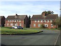
Council Housing - Parkfield Grove
The shortage of available land within the borough was a constraint to the advent of organised council house building. The Parkfield Estate was built in the early 1920s on the former Parkfield Colliery site. This small group of 1960s is fitted in behind the church on Dixon Street.
Image: © John M
Taken: 30 Oct 2010
0.02 miles
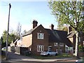
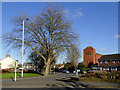
2
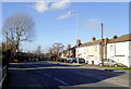
Thompson Avenue in Parkfield, Wolverhampton
This is the A4123 from Birmingham on its way towards Wolverhampton city centre.
Image: © Roger D Kidd
Taken: 11 Feb 2016
0.02 miles
3
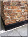
OS benchmark - no 26 Thompson Avenue
An OS cutmark in the bricks at the front of no 26 Thompson Avenue, Parkfield. Originally levelled at 153.516m above Ordnance Datum Newlyn.
Image: © Richard Law
Taken: 13 Aug 2013
0.02 miles
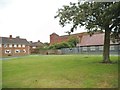
4
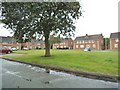
Parkfield Grove Green
The view of the Green in Rough Hills, Wolverhampton.
Image: © Gordon Griffiths
Taken: 4 Aug 2013
0.04 miles
5
Council Housing - Thompson Avenue
Early 1920s council housing on the Parkfield Estate. More properties are packed in behind in Barnard Place.
Image: © John M
Taken: 30 Oct 2010
0.04 miles
6
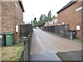
Barnard Place
The view from Thompson Avenue in Wolverhampton.
Image: © Gordon Griffiths
Taken: 4 Aug 2013
0.05 miles
7
Parkfield Grove View
The view across the green towards St Martin's Church in Wolverhampton. The church.Image
Image: © Gordon Griffiths
Taken: 4 Aug 2013
0.05 miles
8
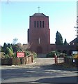
St Martin of Tours
Catholic Church off the Wolverhampton to Birmingham Road in Parkfield. An early church design by local architect Richard Twentyman completed in 1939.
Image: © John M
Taken: 18 Nov 2006
0.05 miles
9

Dixon Street Junction
The view in Parkfields, Wolverhampton.
Image: © Gordon Griffiths
Taken: 27 May 2013
0.05 miles
10
Dixon Street in Parkfields, Wolverhampton
This shows the slip road leading into Dixon Street from Thompson Avenue. St Martin's Church is the imposing red brick building dating from 1939.
Image: © Roger D Kidd
Taken: 11 Feb 2016
0.06 miles