IMAGES TAKEN NEAR TO
Dudley Road, WOLVERHAMPTON, WV2 3JY
Introduction
This page details the photographs taken nearby to Dudley Road, WV2 3JY by members of the Geograph project.
The Geograph project started in 2005 with the aim of publishing, organising and preserving representative images for every square kilometre of Great Britain, Ireland and the Isle of Man.

There are currently over 7.5m images from over14,400 individuals and you can help contribute to the project by visiting https://www.geograph.org.uk
Image Map
Images are licensed for reuse under creativecommons.org/licenses/by-sa/2.0
Notes
- Clicking on the map will re-center to the selected point.
- The higher the marker number, the further away the image location is from the centre of the postcode.
Image Listing (198 Images Found)
Images are licensed for reuse under creativecommons.org/licenses/by-sa/2.0
Image
Details
Distance
1
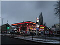
Cheap Petrol
The Blakenhall garage selling 139.6 petrol in Dudley Road, Wolverhampton.
Image: © Gordon Griffiths
Taken: 12 Dec 2022
0.01 miles
2
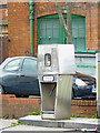
Paraffin pump in Dudley Road, Wolverhampton
Texaco Petrol Station in Dudley Road near Fighting Cocks. This is the last place I know locally where a five gallon container can still be filled with loose paraffin.
Image: © Roger Kidd
Taken: 20 Apr 2012
0.01 miles
3
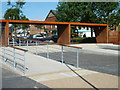
Phoenix Park
The entrance from Dudley Street Blakenhall.
Image: © Gordon Griffiths
Taken: 16 Jul 2008
0.01 miles
4
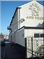
Old Ash Tree
A Bank's Pub on Dudley Road Blakenhall.
Image: © Gordon Griffiths
Taken: 16 Jul 2008
0.03 miles
5
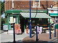
Sandy's Fruit & Veg.
A Shop in Dudley Road Blakenhall.
Image: © Gordon Griffiths
Taken: 16 Jul 2008
0.03 miles
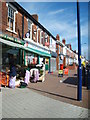
7
Poplar Street
The view in Blakenhall, Wolverhampton.
Image: © Gordon Griffiths
Taken: 17 Mar 2013
0.04 miles
8
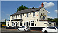
The Old Ash Tree near Blakenhall in Wolverhampton
This pub is currently subject to planning applications leading towards conversion into residential and retail use. Some land and behind the pub has already been sold.
Image: © Roger Kidd
Taken: 20 Jul 2021
0.04 miles
9
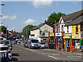
Dudley Road north-west of Fighting Cocks, Wolverhampton
A telephoto assisted image looking north-west along the A459 towards Wolverhampton. Considerable "change of use" is being planned for the Old Ash Tree public house in the near future.
Image: © Roger Kidd
Taken: 20 Jul 2021
0.05 miles
10
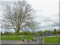
Phoenix Park near Blakenhall, Wolverhampton
This pleasant green area is between Blakenhall and Rough Hills.
The land here was a coalmine for hundreds of years, until becoming a park for the people of Blakenhall in the 1960s.
Image: © Roger Kidd
Taken: 20 Apr 2012
0.05 miles