IMAGES TAKEN NEAR TO
Strode Road, WOLVERHAMPTON, WV2 3ER
Introduction
This page details the photographs taken nearby to Strode Road, WV2 3ER by members of the Geograph project.
The Geograph project started in 2005 with the aim of publishing, organising and preserving representative images for every square kilometre of Great Britain, Ireland and the Isle of Man.

There are currently over 7.5m images from over14,400 individuals and you can help contribute to the project by visiting https://www.geograph.org.uk
Image Map
Images are licensed for reuse under creativecommons.org/licenses/by-sa/2.0
Notes
- Clicking on the map will re-center to the selected point.
- The higher the marker number, the further away the image location is from the centre of the postcode.
Image Listing (322 Images Found)
Images are licensed for reuse under creativecommons.org/licenses/by-sa/2.0
Image
Details
Distance
1
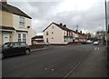
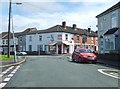
Strode Road Junction
The view in Blakenhall, Wolverhampton.
Image: © Gordon Griffiths
Taken: 17 Mar 2013
0.02 miles
2
Haggar Street Path
The path across open land to Strode Road in Blakenhall, Wolverhampton.
Image: © Gordon Griffiths
Taken: 18 Jul 2012
0.04 miles
3
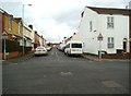
Talbot Road
The view in Blakenhall, Wolverhampton.
Image: © Gordon Griffiths
Taken: 17 Mar 2013
0.04 miles
4
Shaw Road in Blakenhall, Wolverhampton
Looking from the junction with Haggar Street towards Wanderers Avenue at the top of the slope.
Image: © Roger D Kidd
Taken: 5 Nov 2010
0.05 miles
5
Shaw Road Shop
The Shop stands on the corner with Ranelagh Road in Blakenhall, Wolverhampton.
Image: © Gordon Griffiths
Taken: 18 Jul 2012
0.05 miles
6
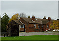
Houses in Blakenhall, Wolverhampton
This shows the back of some late Victorian terraced houses in Haggar Street seen across an area of well kept grass which has replaced houses already demolished. Another area between the backs of the houses to the right is derelict, so I hope when that is redeveloped, the open area remains.
Image: © Roger D Kidd
Taken: 5 Nov 2010
0.06 miles
7
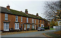
Terraced housing in Blakenhall, Wolverhampton
This Late Victorian housing is at the edge of the Blakenhall Gardens regeneration area. The last of the six high rise blocks (Phoenix Rise) is at present being demolished just off the image to the right.
Image: © Roger D Kidd
Taken: 5 Nov 2010
0.06 miles
8

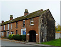
Terraced housing in Blakenhall, Wolverhampton
The end of a late Victorian terrace in Haggar Street. The arched entrance leads through to a near derelict enclosed area of what might originally have been small industrial workshops behind the houses. Local information about these industries will be appreciated.
Note 6.11.2015 Was the arch at the end a drayman's entrance to a demolished public house? What was its name. This used to be part of Cross Street South before the 1960s. Was the house with the blue blinds a butcher's shop? Who owned it?
The white protective covering of the Phoenix Rise tower block, presently undergoing demolition can be seen on the right. The grassy area just beyond the archway has replaced an earlier demolition programme of old housing.
Image: © Roger D Kidd
Taken: 5 Nov 2010
0.06 miles
9
Housing in Blakenhall, Wolverhampton
A late Victorian terrace in Haggar Street. The arched entrance leads through to a near derelict enclosed area of what might have been small workshops behind the houses. Can anyone local mail me with information please? :-)
Image: © Roger D Kidd
Taken: 5 Nov 2010
0.06 miles
10
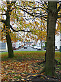
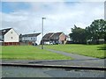
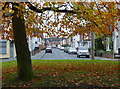
Autumn trees in Blakenhall, Wolverhampton
Looking towards Shaw Road, with Haggar Street to the right, Ranelegh Road to the left.
A small group of mature trees has been left in their minor landscaping, waiting to be an attractive part of extensive regeneration which will follow the demolition of the last of six tower blocks nearby. A lot of land is ready for building to start, behind the camera.
Image: © Roger D Kidd
Taken: 5 Nov 2010
0.06 miles