IMAGES TAKEN NEAR TO
Dudley Road, WOLVERHAMPTON, WV2 3BP
Introduction
This page details the photographs taken nearby to Dudley Road, WV2 3BP by members of the Geograph project.
The Geograph project started in 2005 with the aim of publishing, organising and preserving representative images for every square kilometre of Great Britain, Ireland and the Isle of Man.

There are currently over 7.5m images from over14,400 individuals and you can help contribute to the project by visiting https://www.geograph.org.uk
Image Map
Images are licensed for reuse under creativecommons.org/licenses/by-sa/2.0
Notes
- Clicking on the map will re-center to the selected point.
- The higher the marker number, the further away the image location is from the centre of the postcode.
Image Listing (369 Images Found)
Images are licensed for reuse under creativecommons.org/licenses/by-sa/2.0
Image
Details
Distance
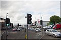
1
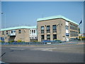
Birmingham Road Nick
The Wolverhampton Police Station stands on the corner of Grove Street.
Image: © Gordon Griffiths
Taken: 28 Jul 2008
0.02 miles
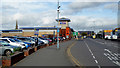
2
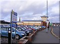
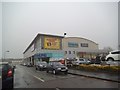
One Pound a Day
The view of the Dudley Road car park in Wolverhampton.
Image: © Gordon Griffiths
Taken: 31 Jan 2013
0.03 miles
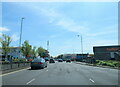
4
Grove Street
The view from the A4123 in Wolverhampton.
Image: © Gordon Griffiths
Taken: 9 Dec 2014
0.04 miles
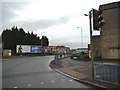
5
Birmingham Road and Grove Street junction
Image: © John Firth
Taken: 26 Aug 2015
0.05 miles
6
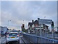
Birmingham Road Lights
The view from Birmingham Road of the junction with Grove Street, Wolverhampton.
Image: © Gordon Griffiths
Taken: 2 Dec 2020
0.05 miles
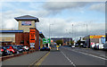
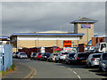
7
Dudley Road approaching Wolverhampton city centre
The A459 from Halesowen and Dudley reaches the city centre here. St John's Retail Park is on the left. The iconic spire of St John's (in the Square) Church can be seen.
Image: © Roger D Kidd
Taken: 12 Oct 2017
0.05 miles
8
Dudley Road approaching Wolverhampton city centre
The A459 from Halesowen and Dudley reaches the city centre here. St John's Retail Park is on the left.
Image: © Roger D Kidd
Taken: 12 Oct 2017
0.05 miles
9
Wolverhampton Bowling
The view of the AMF Bowling Alley in Howard Street on a wet foggy day in Wolverhampton.
Image: © Gordon Griffiths
Taken: 8 Mar 2013
0.06 miles
10
Bell Place in Wolverhampton
A telephoto assisted image, looking north towards the St John's Retail Park.
Image: © Roger D Kidd
Taken: 12 Oct 2017
0.06 miles