IMAGES TAKEN NEAR TO
Dudley Road, WOLVERHAMPTON, WV2 3AQ
Introduction
This page details the photographs taken nearby to Dudley Road, WV2 3AQ by members of the Geograph project.
The Geograph project started in 2005 with the aim of publishing, organising and preserving representative images for every square kilometre of Great Britain, Ireland and the Isle of Man.

There are currently over 7.5m images from over14,400 individuals and you can help contribute to the project by visiting https://www.geograph.org.uk
Image Map
Images are licensed for reuse under creativecommons.org/licenses/by-sa/2.0
Notes
- Clicking on the map will re-center to the selected point.
- The higher the marker number, the further away the image location is from the centre of the postcode.
Image Listing (214 Images Found)
Images are licensed for reuse under creativecommons.org/licenses/by-sa/2.0
Image
Details
Distance
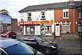
2
Dudley Road
The view from the corner of Johnson Street down the A459 in Blakenhall Wolverhampton.
Image: © Gordon Griffiths
Taken: 14 Mar 2013
0.03 miles
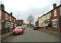
3
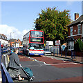
Pedestrian crossing in Dudley Road, Wolverhampton
Beep-beep-beep-beep ...
Looking north, terraced housing is on the right, and three storey shops and housing is off to the left.
The bus is a Transbus Trident new to West Midlands Travel (Fleet No 4595) in 2004.
Image: © Roger Kidd
Taken: 29 Sep 2007
0.03 miles
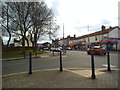
4
Johnson Street Seats
This small seated area stands on the corner of Johnson Street and the very busy A459 Dudley Road, Wolverhampton.
Image: © Gordon Griffiths
Taken: 12 Sep 2010
0.03 miles
5
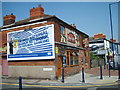
Kings Arms
The Pub stands on Dudley Road at the corner with Sedgley Street.
Image: © Gordon Griffiths
Taken: 28 Jul 2008
0.04 miles
6
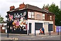
Former King's Arms on Dudley Road
This was a former Mitchells and Butlers Public House Imagethat probably saw falling trade when the tower blocks were demolished and the area re-developed.
CoCo's Dessert Factory was registered with Companies House on 27 May 2016.
Image: © John M
Taken: 27 May 2016
0.04 miles
7
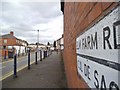
Elm Farm Road
The view of the Cul-de-sac off Dudley Road, Blakenhall Wolverhampton.
Image: © Gordon Griffiths
Taken: 14 Mar 2013
0.04 miles
8
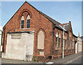
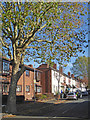
Pountney Street Methodist Church (Disused)
See http://www.wolvesmethodism.mikejackson.org.uk/Pountney%20Street/index.html
Image: © Mike Jackson
Taken: Unknown
0.07 miles
9
Housing in Mason Street, Wolverhampton
Looking east, Mason Street links Lower Villers Street with Dudley Road.
Image: © Roger Kidd
Taken: 2 Nov 2018
0.07 miles
10
Mason Street
The view in Blakenhall, Wolverhampton.
Image: © Gordon Griffiths
Taken: 12 Mar 2013
0.07 miles