IMAGES TAKEN NEAR TO
Ettingshall Road, WOLVERHAMPTON, WV2 2RS
Introduction
This page details the photographs taken nearby to Ettingshall Road, WV2 2RS by members of the Geograph project.
The Geograph project started in 2005 with the aim of publishing, organising and preserving representative images for every square kilometre of Great Britain, Ireland and the Isle of Man.

There are currently over 7.5m images from over14,400 individuals and you can help contribute to the project by visiting https://www.geograph.org.uk
Image Map
Images are licensed for reuse under creativecommons.org/licenses/by-sa/2.0
Notes
- Clicking on the map will re-center to the selected point.
- The higher the marker number, the further away the image location is from the centre of the postcode.
Image Listing (144 Images Found)
Images are licensed for reuse under creativecommons.org/licenses/by-sa/2.0
Image
Details
Distance
1
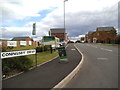
Coningsby Drive
The view from the A4126 Ettingshall Road of the former Tyre Recycling Plant site now a housing development.
Image: © Gordon Griffiths
Taken: 8 Sep 2013
0.02 miles
2
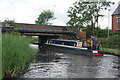
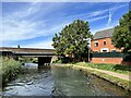
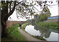
Catchems Corner Bridge, BCN Main Line
'Emily' takes it steady through the oddly-named Catchems Corner Bridge which carries Ettingshall Road over the canal.
Image: © Stephen McKay
Taken: 8 Aug 2014
0.02 miles
3
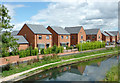
New canalside housing near Ettingshall, Wolverhampton
This shows new housing by the Birmingham Main Line Canal, seen from the A4126 road bridge near Catchem's Corner.
October 2010 Image]
Image: © Roger D Kidd
Taken: 11 Aug 2013
0.03 miles
5
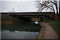
Ettingshall Road bridge
Over the Birmingham Canal.
Image: © Andrew Abbott
Taken: 13 Sep 2022
0.03 miles
6
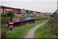
Tyre recycling in Bilston
The natives have their own way of recycling tyres. Here is one way, dump them outside the closed incinerator. ImageThis site is earmarked to be redeveloped for housing.
Image: © John M
Taken: 28 Oct 2006
0.03 miles
7
Narrowboat Saltaire near Ettingshall, Wolverhampton
This is east of Catchems Corner Bridge on the Wolverhampton Level of the Birmingham Main Line Canal, which was fully opened in 1772. James Brindley was the engineer. Thomas Telford upgraded the route some sixty years later.
The seventy foot long working boat is a 1936 registered GUCCC (Grand Union Canal Carrying Company) narrowboat, Saltaire No 167, originally paired with butty No 349 Saltley, but not all is quite as it seems. If this were a car, it would be condemned as a "cut-and-shut" job. Only the front end is actually the original Saltaire. The original engine room end was cut off by British Waterways in the 1960s while being used as a maintenance craft, and that now forms part of another (pleasure) vessel. The present stern end and engine room is from 1987.
Image: © Roger D Kidd
Taken: 15 Oct 2010
0.03 miles
8
Ettingshall Road Bridge
The view of Catchems Corner Bridge on the Birmingham Canal in Ettingshall, Wolverhampton.
Image: © Gordon Griffiths
Taken: 8 Sep 2013
0.03 miles
9
Birmingham Canal towards Catchens Corner Bridge
Image: © Ian S
Taken: 16 Dec 2021
0.03 miles
10
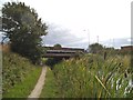
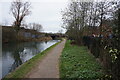
Birmingham Main Line Canal near Priestfield, Wolverhampton
This is a dull morning north-west of Catchems Corner Bridge on the Wolverhampton Level of the Birmingham Main Line Canal, which was fully opened in 1772. James Brindley was the engineer. Thomas Telford upgraded the route some sixty years later.
A working boat is approaching.
Image: © Roger D Kidd
Taken: 15 Oct 2010
0.04 miles