IMAGES TAKEN NEAR TO
Kirton Place, WOLVERHAMPTON, WV2 2RR
Introduction
This page details the photographs taken nearby to Kirton Place, WV2 2RR by members of the Geograph project.
The Geograph project started in 2005 with the aim of publishing, organising and preserving representative images for every square kilometre of Great Britain, Ireland and the Isle of Man.

There are currently over 7.5m images from over14,400 individuals and you can help contribute to the project by visiting https://www.geograph.org.uk
Image Map
Images are licensed for reuse under creativecommons.org/licenses/by-sa/2.0
Notes
- Clicking on the map will re-center to the selected point.
- The higher the marker number, the further away the image location is from the centre of the postcode.
Image Listing (169 Images Found)
Images are licensed for reuse under creativecommons.org/licenses/by-sa/2.0
Image
Details
Distance
1
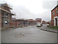
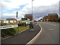
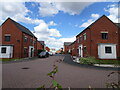
Duxford Grove
The view on Ettingshall Place, a new housing development in Bilston.
Image: © Gordon Griffiths
Taken: 22 Apr 2014
0.03 miles
2
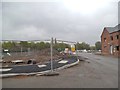
Coningsby Drive View
The view on Ettingshall Place, a new housing development in Bilston.
Image: © Gordon Griffiths
Taken: 22 Apr 2014
0.05 miles
3
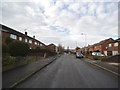
Frost Street view
The view in Ettingshall, Bilston.
Image: © Gordon Griffiths
Taken: 21 Jan 2014
0.05 miles
4
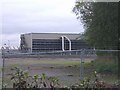
Energy from Waste, Tyre Recycling Plant
Originally built for Elm Energy in the early 1990s this plant was sold to French business SITA in 1998 and eventually closed in 2000. It was designed to take up to 100,000 tyres per year for incineration with energy being sold to Powergen. It proved very unpopular with local residents and never lived up to expectations.
Image: © John M
Taken: 28 Oct 2006
0.06 miles
5
Coningsby Drive
The view from the A4126 Ettingshall Road of the former Tyre Recycling Plant site now a housing development.
Image: © Gordon Griffiths
Taken: 8 Sep 2013
0.06 miles
6
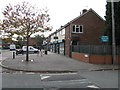
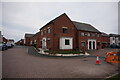
New Street Shops, Sittinghall Village, Priestfield
Image: © Peter Whatley
Taken: 22 Oct 2008
0.07 miles
7
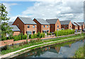
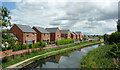
New canalside housing near Ettingshall, Wolverhampton
This shows new housing by the Birmingham Main Line Canal, seen from the A4126 road bridge near Catchem's Corner.
October 2010 Image]
Image: © Roger D Kidd
Taken: 11 Aug 2013
0.08 miles
9
Duxford Grove
The view from the Birmingham Canal in Ettingshall, Wolverhampton.
Image: © Gordon Griffiths
Taken: 27 Jun 2022
0.08 miles
10
Birmingham Main Line Canal near Ettingshall, Wolverhampton
This shows new housing by the Birmingham Main Line Canal (Wolverhampton Level), seen from the A4126 road bridge near Catchem's Corner.
See also this image from October 2010: Image]
Image: © Roger D Kidd
Taken: 11 Aug 2013
0.08 miles