IMAGES TAKEN NEAR TO
Pembroke Avenue, WOLVERHAMPTON, WV2 2JY
Introduction
This page details the photographs taken nearby to Pembroke Avenue, WV2 2JY by members of the Geograph project.
The Geograph project started in 2005 with the aim of publishing, organising and preserving representative images for every square kilometre of Great Britain, Ireland and the Isle of Man.

There are currently over 7.5m images from over14,400 individuals and you can help contribute to the project by visiting https://www.geograph.org.uk
Image Map
Images are licensed for reuse under creativecommons.org/licenses/by-sa/2.0
Notes
- Clicking on the map will re-center to the selected point.
- The higher the marker number, the further away the image location is from the centre of the postcode.
Image Listing (119 Images Found)
Images are licensed for reuse under creativecommons.org/licenses/by-sa/2.0
Image
Details
Distance

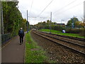
2
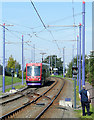
The Midlands Metro at Priestfield, Wolverhampton
While St George's station was closed for maintenance, and the tram at The Royal broke down (stranding another on the same line), this "training" tram was suddenly required to take us all to Birmingham, from Priestfield.
Image: © Roger D Kidd
Taken: 27 Sep 2008
0.02 miles
3
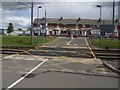
Exit from Priestfield Metro Stop car park
Unlike a railway crossing there are no lights or barriers. Following a fatality five years ago there have been some changes made to improve visibility for motorists.
Image: © John M
Taken: 12 Jul 2008
0.02 miles
4
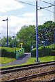
Footpath to the Priestfield park & ride site, Wolverhampton
The footpath connects the park & ride car park with the tram stop.
Image: © P L Chadwick
Taken: 11 Jun 2011
0.03 miles
5
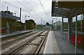
Priestfield Midland Metro Station prior to opening, looking towards Wolverhampton.
The brand new and yet to be opened Priestfield Midland Metro Station, looking towards Wolverhampton. In the distance the track can be seen to swing left and climb away towards the A41 en route for Wolverhampton St Georges. The old Great Western Main Line would have continued straight on beneath the A41 at this point.
Image: © Tim Marshall
Taken: 20 Sep 1998
0.04 miles
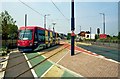
6
Tram Stop View
The view towards the Midland Metro Priestfield Station off Bilston Road in Wolverhampton.
Image: © Gordon Griffiths
Taken: 24 Oct 2024
0.05 miles
7
Midland Metro tram 07 about to enter Bilston Road
The Midland Metro runs just one light rail line, between Birmingham Snow Hill railway station and the centre of Wolverhampton. The majority of it follows a former railway line between the two places, but on the approach to Wolverhampton it changes into a traditional street running tramway. This view shows tram 07 about to leave the former railway line section and enter Bilston Road. This was photographed a few weeks after the line opened in 1999.
Image: © P L Chadwick
Taken: Unknown
0.05 miles
8
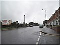
Holloway Street View
The view down Bilston Road (A41) in Stow Heath, Wolverhampton.
Image: © Gordon Griffiths
Taken: 17 Sep 2013
0.05 miles
9
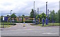
Entrance to Priestfield Metro Stop Car Park, Bilston Road, Wolverhampton
Park and ride site near the Priestfield tram stop.
Image: © P L Chadwick
Taken: 11 Jun 2011
0.05 miles
10
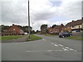
Pembroke Avenue View
The view from Hincks Street, Ettingshall, Bilston.
Image: © Gordon Griffiths
Taken: 20 Aug 2013
0.06 miles