IMAGES TAKEN NEAR TO
Cooper Street, WOLVERHAMPTON, WV2 2JL
Introduction
This page details the photographs taken nearby to Cooper Street, WV2 2JL by members of the Geograph project.
The Geograph project started in 2005 with the aim of publishing, organising and preserving representative images for every square kilometre of Great Britain, Ireland and the Isle of Man.

There are currently over 7.5m images from over14,400 individuals and you can help contribute to the project by visiting https://www.geograph.org.uk
Image Map
Images are licensed for reuse under creativecommons.org/licenses/by-sa/2.0
Notes
- Clicking on the map will re-center to the selected point.
- The higher the marker number, the further away the image location is from the centre of the postcode.
Image Listing (122 Images Found)
Images are licensed for reuse under creativecommons.org/licenses/by-sa/2.0
Image
Details
Distance
1
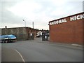
National Hickman
The view of a building supplier in an industrial area of Wolverhampton.
Image: © Gordon Griffiths
Taken: 30 Sep 2013
0.03 miles
2
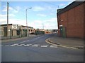
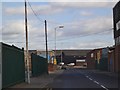
Cooper Street
The view down the Wolverhampton street in an industrial area of the city.
Image: © Gordon Griffiths
Taken: 2 Sep 2013
0.04 miles
3
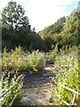
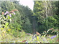
Sutherland Avenue Stairs
The view down the stairs to the Wolverhampton Path along a former railway line, in an industrial area of the city.
Image: © Gordon Griffiths
Taken: 2 Sep 2013
0.04 miles
4
Railway Path Steps
The view in Sutherland Avenue down the stairs to the Wolverhampton Path along a former railway line, in an industrial area of the city.
Image: © Gordon Griffiths
Taken: 27 Jun 2022
0.04 miles
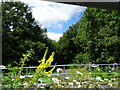
5
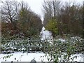
Sutherland Avenue Path
The view down the Wolverhampton Path along a former railway line, in an industrial area of the city.
Image: © Gordon Griffiths
Taken: 2 Sep 2013
0.04 miles
6
Path View
The view of the former Railway line to Wolverhampton Lower level Station, from Sutherland Avenue.
Image: © Gordon Griffiths
Taken: 12 Dec 2022
0.06 miles
7
Cooper Street Bend
The view down the Wolverhampton street in an industrial area of the city.
Image: © Gordon Griffiths
Taken: 2 Sep 2013
0.06 miles
8

Sutherland Avenue Path View
The view down the Wolverhampton Path along a former railway line, in the Monmore Green industrial area of the city.
Image: © Gordon Griffiths
Taken: 2 Sep 2013
0.07 miles
9
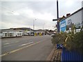
Bilston Road View
The view down the A41 in Wolverhampton.
Image: © Gordon Griffiths
Taken: 30 Sep 2013
0.07 miles
10
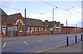
The Kings Hall, Bilston Road, Wolverhampton
This was formerly a school but is now used as a luxury venue for parties, special events, conferences and seminars.
Image: © P L Chadwick
Taken: 11 Jun 2011
0.07 miles