IMAGES TAKEN NEAR TO
Furnace Drive, WOLVERHAMPTON, WV2 2FF
Introduction
This page details the photographs taken nearby to Furnace Drive, WV2 2FF by members of the Geograph project.
The Geograph project started in 2005 with the aim of publishing, organising and preserving representative images for every square kilometre of Great Britain, Ireland and the Isle of Man.

There are currently over 7.5m images from over14,400 individuals and you can help contribute to the project by visiting https://www.geograph.org.uk
Image Map
Images are licensed for reuse under creativecommons.org/licenses/by-sa/2.0
Notes
- Clicking on the map will re-center to the selected point.
- The higher the marker number, the further away the image location is from the centre of the postcode.
Image Listing (131 Images Found)
Images are licensed for reuse under creativecommons.org/licenses/by-sa/2.0
Image
Details
Distance
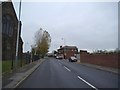
1
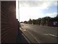
Cable Street View
The view up the Wolverhampton street,in an industrial area of the city.
Image: © Gordon Griffiths
Taken: 2 Sep 2013
0.04 miles
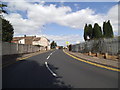
2
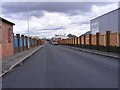
Cable Street
The view down the Wolverhampton Street.
Image: © Gordon Griffiths
Taken: 20 Apr 2012
0.05 miles
3
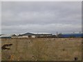
Cable Street Wasteland View
The view north from the Wolverhampton street,in an industrial area of the city. The wasteland is bordered to the east by the Birmingham canal.
Image: © Gordon Griffiths
Taken: 6 Dec 2013
0.06 miles
4
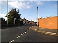
Cable Street Junction View
The view up the Wolverhampton street,in an industrial area of the city.
Image: © Gordon Griffiths
Taken: 2 Sep 2013
0.06 miles
5
Steelhouse Lane View
The view next to All Saints Church looking towards the Summerhouse Pub in Wolverhampton.
Image: © Gordon Griffiths
Taken: 16 Nov 2013
0.08 miles
6

Cable Street Wasteland
The view north from the Wolverhampton street,in an industrial area of the city. The wasteland is bordered to the east by the Birmingham canal.
Image: © Gordon Griffiths
Taken: 2 Sep 2013
0.09 miles
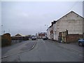
7
Mills Road
The view in All Saints, Wolverhampton.
Image: © Gordon Griffiths
Taken: 16 Nov 2013
0.09 miles
8
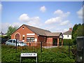
Medical Centre in Monmore Green
This is on the corner of Steelhouse Lane and (guess what?) Caledonia Road.
Image: © Richard Law
Taken: 23 Apr 2009
0.10 miles
9
Caledonia Road View
The view near the junction with Major Street in All Saints, Wolverhampton.
Image: © Gordon Griffiths
Taken: 16 Nov 2013
0.10 miles
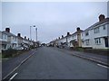
10
Major Street Bend
The view in Blakenhall, Wolverhampton.
Image: © Gordon Griffiths
Taken: 31 Aug 2013
0.10 miles