IMAGES TAKEN NEAR TO
Beech Tree Road, WOLVERHAMPTON, WV2 2FD
Introduction
This page details the photographs taken nearby to Beech Tree Road, WV2 2FD by members of the Geograph project.
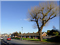
The Geograph project started in 2005 with the aim of publishing, organising and preserving representative images for every square kilometre of Great Britain, Ireland and the Isle of Man.

There are currently over 7.5m images from over14,400 individuals and you can help contribute to the project by visiting https://www.geograph.org.uk
Image Map
Images are licensed for reuse under creativecommons.org/licenses/by-sa/2.0
Notes
- Clicking on the map will re-center to the selected point.
- The higher the marker number, the further away the image location is from the centre of the postcode.
Image Listing (127 Images Found)
Images are licensed for reuse under creativecommons.org/licenses/by-sa/2.0
Image
Details
Distance
1
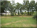
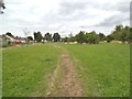
Thompson Avenue Park Wood
The view of the parkland behind the houses on the A4123 in Wolverhampton.
Image: © Gordon Griffiths
Taken: 27 Jul 2013
0.03 miles
2
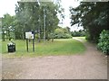
Thompson Avenue Park
The view in Blakenhall, Wolverhampton.
Image: © Gordon Griffiths
Taken: 27 Jul 2013
0.04 miles
3
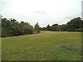
Park View
The view in Thompson Avenue Park, Wolverhampton.
Image: © Gordon Griffiths
Taken: 27 Jul 2013
0.05 miles
4
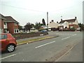
Willcock Road
The view towards Dixon Street in Rough Hills, Wolverhampton.
Image: © Gordon Griffiths
Taken: 27 Jul 2013
0.05 miles
5
Dixon Street near Rough Hills, Wolverhampton
Dixon Street links the A4123 (Thompson Avenue) with the A41 (Bilston Road).
Image: © Roger D Kidd
Taken: 11 Feb 2016
0.05 miles
6
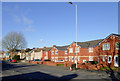
New housing in Thompson Avenue, Wolverhampton
The new red-brick housing on the right hand half of the image is on the site of the former Black Horse public house.
Image: © Roger D Kidd
Taken: 11 Feb 2016
0.06 miles
7
Housing in Thompson Avenue, Wolverhampton
The new red-brick house on the right is on the site of the former Black Horse public house.
Image: © Roger D Kidd
Taken: 11 Feb 2016
0.06 miles
8
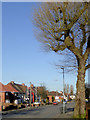
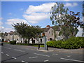
Housing in Dixon Street, near Rough Hills, Wolverhampton
Dixon Street links the A4123 (Thompson Avenue) with the A41 (Bilston Road).
Image: © Roger D Kidd
Taken: 11 Feb 2016
0.07 miles
9
Park Path
The view in Thompson Avenue Park, Wolverhampton.
Image: © Gordon Griffiths
Taken: 6 Aug 2013
0.07 miles
10
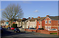
Housing on Thompson Avenue, Parkfield
The 1920s council housing on Thompson Avenue was built to a distinctive style, with shared porches under gables. Some were semi detached, whereas others (like those in the foreground) were built as short terraces of four houses with a covered passage in the centre.
Image: © Richard Vince
Taken: 3 Jun 2013
0.07 miles