IMAGES TAKEN NEAR TO
Myatt Avenue, WOLVERHAMPTON, WV2 2ED
Introduction
This page details the photographs taken nearby to Myatt Avenue, WV2 2ED by members of the Geograph project.
The Geograph project started in 2005 with the aim of publishing, organising and preserving representative images for every square kilometre of Great Britain, Ireland and the Isle of Man.

There are currently over 7.5m images from over14,400 individuals and you can help contribute to the project by visiting https://www.geograph.org.uk
Image Map
Images are licensed for reuse under creativecommons.org/licenses/by-sa/2.0
Notes
- Clicking on the map will re-center to the selected point.
- The higher the marker number, the further away the image location is from the centre of the postcode.
Image Listing (131 Images Found)
Images are licensed for reuse under creativecommons.org/licenses/by-sa/2.0
Image
Details
Distance
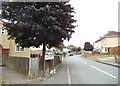
1

Joan Street View
The view down the cul-de-sac in Rough Hills, Wolverhampton.
Image: © Gordon Griffiths
Taken: 1 Aug 2013
0.04 miles
2
Joan Street
The view in Rough Hills, Wolverhampton.
Image: © Gordon Griffiths
Taken: 27 Jul 2013
0.05 miles
3
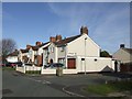
Council Housing - Legge Street
The shortage of available land within the borough was a constraint to the advent of organised council house building. The Parkfield Estate was built in the early 1920s on the former Parkfield Colliery site.
Many properties have been sold under 'Right to Buy'.
Image: © John M
Taken: 30 Oct 2010
0.05 miles
4
Whittaker Street
The view in Rough Hills, Wolverhampton.
Image: © Gordon Griffiths
Taken: 27 Jul 2013
0.06 miles
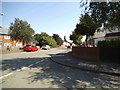
5
Dixon Street
The view in Parkfield, Wolverhampton.
Image: © Gordon Griffiths
Taken: 15 May 2013
0.06 miles
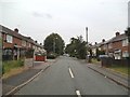
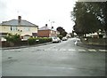
6
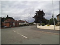
Myatt Avenue Junction
The view at the junction with Dixon Street in Rough Hills, Wolverhampton.
Image: © Gordon Griffiths
Taken: 30 Jul 2013
0.06 miles
7
Myatt Close
The view in Rough Hills, Wolverhampton.
Image: © Gordon Griffiths
Taken: 1 Aug 2013
0.06 miles
8
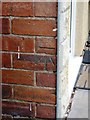
OS benchmark - no 128 Dixon Street
An OS cutmark in the bricks near the front door of 128 Dixon Street; originally levelled at 151.361m above Ordnance Datum Newlyn.
Image: © Richard Law
Taken: 13 Aug 2013
0.07 miles
9
Myatt Avenue Scene
The view in Rough Hills, Wolverhampton.
Image: © Gordon Griffiths
Taken: 1 Aug 2013
0.07 miles
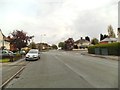
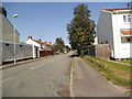
10
Wheatley Street
The view from Myatt Avenue in Rough Hills, Wolverhampton.
Image: © Gordon Griffiths
Taken: 4 Aug 2013
0.08 miles