IMAGES TAKEN NEAR TO
Parkfield Grove, WOLVERHAMPTON, WV2 2DG
Introduction
This page details the photographs taken nearby to Parkfield Grove, WV2 2DG by members of the Geograph project.
The Geograph project started in 2005 with the aim of publishing, organising and preserving representative images for every square kilometre of Great Britain, Ireland and the Isle of Man.

There are currently over 7.5m images from over14,400 individuals and you can help contribute to the project by visiting https://www.geograph.org.uk
Image Map
Images are licensed for reuse under creativecommons.org/licenses/by-sa/2.0
Notes
- Clicking on the map will re-center to the selected point.
- The higher the marker number, the further away the image location is from the centre of the postcode.
Image Listing (147 Images Found)
Images are licensed for reuse under creativecommons.org/licenses/by-sa/2.0
Image
Details
Distance
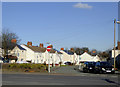
1
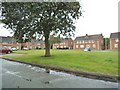
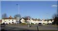
Parkfield Grove Green
The view of the Green in Rough Hills, Wolverhampton.
Image: © Gordon Griffiths
Taken: 4 Aug 2013
0.03 miles
2
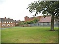
Parkfield Grove View
The view across the green towards St Martin's Church in Wolverhampton. The church.Image
Image: © Gordon Griffiths
Taken: 4 Aug 2013
0.03 miles
3
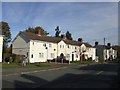
Council Housing - Parkfield Crescent
The shortage of available land within the borough was a constraint to the advent of organised council house building. The Parkfield Estate was built in the early 1920s on the former Parkfield Colliery site.
Council house sales under 'Right to Buy' show up with modifications to properties either by owners or improvements by the council. The abandoned sofa suggests a council property.
Image: © John M
Taken: 30 Oct 2010
0.04 miles
4
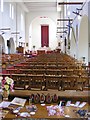
St Martin's Interior
The view of the Church of England church in Dixon Street Wolverhampton.The high church architect of the 1939 building was Richard Twentyman.
Image: © Gordon Griffiths
Taken: 10 Sep 2011
0.05 miles
5
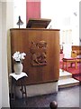
St Martin's Pulpit
The inside view of the Church of England church in Dixon Street Wolverhampton.The oak lamb on the high church pulpit was carved by Donald Potter and the architect of the 1939 building was Richard Twentyman.
Image: © Gordon Griffiths
Taken: 10 Sep 2011
0.05 miles
6
Council Housing - Parkfield Grove
The shortage of available land within the borough was a constraint to the advent of organised council house building. The Parkfield Estate was built in the early 1920s on the former Parkfield Colliery site. This small group of 1960s is fitted in behind the church on Dixon Street.
Image: © John M
Taken: 30 Oct 2010
0.05 miles
7
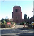
St Martin of Tours
Catholic Church off the Wolverhampton to Birmingham Road in Parkfield. An early church design by local architect Richard Twentyman completed in 1939.
Image: © John M
Taken: 18 Nov 2006
0.05 miles
8
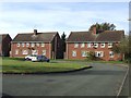
Housing in Parkfield, Wolverhampton
Looking across the dual carriageway from Thompson Avenue towards the houses in Parkfield Crescent.
Image: © Roger D Kidd
Taken: 11 Feb 2016
0.06 miles
9
Parkfield Crescent in Parkfield, Wolverhampton
Looking across the dual carriageway from Thompson Avenue towards the houses in Parkfield Crescent.
Image: © Roger D Kidd
Taken: 11 Feb 2016
0.06 miles
10
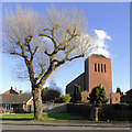
St Martin's Church in Parkfield (Rough Hills), Wolverhampton
The church is in Dixon Street, and is dedicated to St Martin of Tours. It was built in 1939 on the site of an old mine. The architect was Richard Twentyman.
Image: © Roger D Kidd
Taken: 11 Feb 2016
0.06 miles