IMAGES TAKEN NEAR TO
Kent Road, WOLVERHAMPTON, WV2 2BB
Introduction
This page details the photographs taken nearby to Kent Road, WV2 2BB by members of the Geograph project.
The Geograph project started in 2005 with the aim of publishing, organising and preserving representative images for every square kilometre of Great Britain, Ireland and the Isle of Man.

There are currently over 7.5m images from over14,400 individuals and you can help contribute to the project by visiting https://www.geograph.org.uk
Image Map
Images are licensed for reuse under creativecommons.org/licenses/by-sa/2.0
Notes
- Clicking on the map will re-center to the selected point.
- The higher the marker number, the further away the image location is from the centre of the postcode.
Image Listing (102 Images Found)
Images are licensed for reuse under creativecommons.org/licenses/by-sa/2.0
Image
Details
Distance
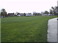
1
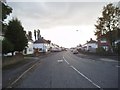
Kent Road View
The view in Blakenhall, Wolverhampton.
Image: © Gordon Griffiths
Taken: 28 Oct 2013
0.04 miles
2
Howell Road Allotments
The view in Blakenhall, Wolverhampton.
Image: © Gordon Griffiths
Taken: 14 Nov 2013
0.05 miles
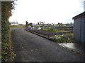
3
Kent Road Allotments
The view in Blakenhall, Wolverhampton.
Image: © Gordon Griffiths
Taken: 6 Aug 2013
0.05 miles
4
Kent Road
The view in Blakenhall, Wolverhampton.
Image: © Gordon Griffiths
Taken: 6 Aug 2013
0.06 miles
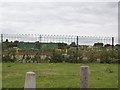
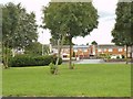
5
Dixon Street Football Fields
The view in Blakenhall, Wolverhampton.
Image: © Gordon Griffiths
Taken: 14 Nov 2013
0.07 miles
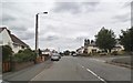
6

Dixon Street View
The view from Rooker Avenue in Rough Hills, Wolverhampton.
Image: © Gordon Griffiths
Taken: 27 May 2013
0.08 miles
7
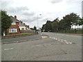
Kent Road Junction
The junction with Pond Lane in Blakenhall, Wolverhampton.
Image: © Gordon Griffiths
Taken: 6 Aug 2013
0.08 miles
8
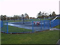
Dixon Street Playpark
The view in Blakenhall, Wolverhampton.
Image: © Gordon Griffiths
Taken: 14 Nov 2013
0.08 miles
9
Pond Crescent
The view from Pond Lane in Blakenhall, Wolverhampton.
Image: © Gordon Griffiths
Taken: 6 Aug 2013
0.08 miles
10
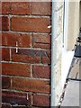
OS benchmark - no 128 Dixon Street
An OS cutmark in the bricks near the front door of 128 Dixon Street; originally levelled at 151.361m above Ordnance Datum Newlyn.
Image: © Richard Law
Taken: 13 Aug 2013
0.09 miles