IMAGES TAKEN NEAR TO
Liana Gardens, WOLVERHAMPTON, WV2 2AD
Introduction
This page details the photographs taken nearby to Liana Gardens, WV2 2AD by members of the Geograph project.
The Geograph project started in 2005 with the aim of publishing, organising and preserving representative images for every square kilometre of Great Britain, Ireland and the Isle of Man.

There are currently over 7.5m images from over14,400 individuals and you can help contribute to the project by visiting https://www.geograph.org.uk
Image Map
Images are licensed for reuse under creativecommons.org/licenses/by-sa/2.0
Notes
- Clicking on the map will re-center to the selected point.
- The higher the marker number, the further away the image location is from the centre of the postcode.
Image Listing (122 Images Found)
Images are licensed for reuse under creativecommons.org/licenses/by-sa/2.0
Image
Details
Distance
2
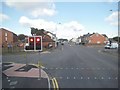
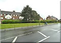
Stowheath Lights
The view from Wellington Road (A41), Bilston.
Image: © Gordon Griffiths
Taken: 15 Aug 2015
0.03 miles
3
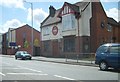
The Gate
The Pub on the Bilston Road at Stow Heath, Wolverhampton.
Image: © Gordon Griffiths
Taken: 29 Jun 2010
0.04 miles
4
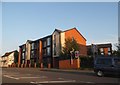
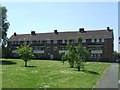
Council Housing - Ward Street
A set of three storey blocks dating from 1950s arranged around grassy courtyard.
Image: © John M
Taken: 6 Jun 2013
0.04 miles
5

Stowheath Post Office
The Post Office on Wellington Road, Bilston.
Image: © Gordon Griffiths
Taken: 19 Jun 2012
0.05 miles
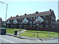
6
Council Housing - Junction Road
A set of three storey blocks dating from 1950s arranged around grassy courtyard.
Image: © John M
Taken: 6 Jun 2013
0.05 miles
7
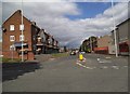
Bilston Road Flats
The view of the Flats off the A41 in Stow Heath, Wolverhampton.
Image: © Gordon Griffiths
Taken: 17 Sep 2013
0.06 miles
8
Ward Street
The view from Hall Park Street, Wolverhampton.
Image: © Gordon Griffiths
Taken: 8 Sep 2013
0.06 miles
9
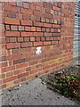
OS benchmark - Priestfield, Elec substation
An OS benchmark on the front wall of the electricity substation near the junction of Wellington Road with Stow Heath Lane. Originally levelled at 136.877m above Ordnance Datum Newlyn.
Image: © Richard Law
Taken: 6 Oct 2013
0.06 miles
10
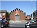
Electricity Substation
Pre-war electricity substation for Wolverhampton District Electric Tramways Company.
Image: © John M
Taken: 6 Jun 2013
0.06 miles