IMAGES TAKEN NEAR TO
Bowdler Road, WOLVERHAMPTON, WV2 1EN
Introduction
This page details the photographs taken nearby to Bowdler Road, WV2 1EN by members of the Geograph project.
The Geograph project started in 2005 with the aim of publishing, organising and preserving representative images for every square kilometre of Great Britain, Ireland and the Isle of Man.

There are currently over 7.5m images from over14,400 individuals and you can help contribute to the project by visiting https://www.geograph.org.uk
Image Map
Images are licensed for reuse under creativecommons.org/licenses/by-sa/2.0
Notes
- Clicking on the map will re-center to the selected point.
- The higher the marker number, the further away the image location is from the centre of the postcode.
Image Listing (114 Images Found)
Images are licensed for reuse under creativecommons.org/licenses/by-sa/2.0
Image
Details
Distance
1
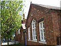
The former All Saints Junior School, Monmore Green
As far as I can discover, the school has closed, and an organisation called The Workspace is using the refurbished buildings as a community enterprise scheme, providing meeting spaces and associated facilities.
Image: © Richard Law
Taken: 22 Apr 2009
0.03 miles
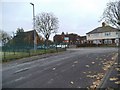
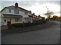
2
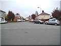
Bowdler Road Junction
The view of the junction with Mills Crescent in All Saints, Wolverhampton.
Image: © Gordon Griffiths
Taken: 16 Nov 2013
0.04 miles
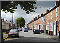
3
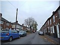
All Saints Road
The view in All Saints, Wolverhampton.
Image: © Gordon Griffiths
Taken: 16 Nov 2013
0.04 miles
4
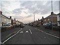
Mills Road View
The view towards Steelhouse Lane in Wolverhampton.
Image: © Gordon Griffiths
Taken: 21 Nov 2013
0.05 miles
5
All Saints Road in Wolverhampton
West of the barrier by Gower Street.
Image: © Roger D Kidd
Taken: 1 Sep 2015
0.05 miles
6
All Saints Scene
The view near All Saints Church in Wolverhampton.
Image: © Gordon Griffiths
Taken: 16 Nov 2013
0.05 miles
7
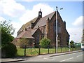
All Saints Church, Wolverhampton
A rather attractive church building on Steelhouse Lane.
Image: © Richard Law
Taken: 22 Apr 2009
0.05 miles
8
All Saints Road in Wolverhampton
West of the barrier by Gower Street.
Image: © Roger D Kidd
Taken: 1 Sep 2015
0.06 miles
9
Mills Road Junction
The view of the junction with Mills Crescent in Blakenhall, Wolverhampton.
Image: © Gordon Griffiths
Taken: 21 Nov 2013
0.06 miles
10
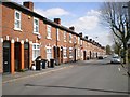
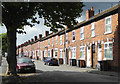
Terraced housing on All Saints Road
A long continuous terrace of houses, all well kept.
Image: © Richard Law
Taken: 22 Apr 2009
0.06 miles