IMAGES TAKEN NEAR TO
St. Johns Court, BRIDGNORTH, WV16 6TQ
Introduction
This page details the photographs taken nearby to St. Johns Court, WV16 6TQ by members of the Geograph project.
The Geograph project started in 2005 with the aim of publishing, organising and preserving representative images for every square kilometre of Great Britain, Ireland and the Isle of Man.

There are currently over 7.5m images from over14,400 individuals and you can help contribute to the project by visiting https://www.geograph.org.uk
Image Map
Images are licensed for reuse under creativecommons.org/licenses/by-sa/2.0
Notes
- Clicking on the map will re-center to the selected point.
- The higher the marker number, the further away the image location is from the centre of the postcode.
Image Listing (43 Images Found)
Images are licensed for reuse under creativecommons.org/licenses/by-sa/2.0
Image
Details
Distance
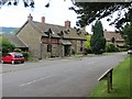
1
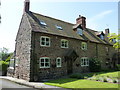
The former Ditton Farmhouse
Dates to the 17th century, albeit much altered in the meantime, and Grade II listed https://britishlistedbuildings.co.uk/101053856-former-ditton-farm-house-ditton-priors#.XVBT_uhKjcs & https://historicengland.org.uk/listing/the-list/list-entry/1053856 in 1974. The 'panelled' central chimney stack is rather unusual.
Image: © Richard Law
Taken: 28 Jun 2019
0.01 miles
2
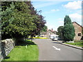
One way road going past the parish church at Ditton Priors
Image: © Basher Eyre
Taken: 9 Aug 2009
0.03 miles
4

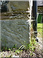
Ordnance Survey Cut Mark
This OS cut mark can be found on the west face of St John the Baptist's Church. It marks a point 231.055m above mean sea level.
Image: © Adrian Dust
Taken: 13 Mar 2017
0.03 miles
5
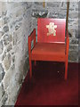
Unusual chair within St John the Baptist, Ditton Priors
Image: © Basher Eyre
Taken: 9 Aug 2009
0.04 miles
6
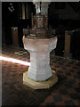
The font at St John the Baptist, Ditton Priors
Image: © Basher Eyre
Taken: 9 Aug 2009
0.04 miles
7
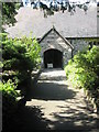
The church porch at St John the Baptist, Ditton Priors
Image: © Basher Eyre
Taken: 9 Aug 2009
0.04 miles
8
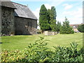
Tombs in the churchyard at St John the Baptist, Ditton Priors
Image: © Basher Eyre
Taken: 9 Aug 2009
0.04 miles
9
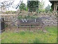
Seat, Ditton Priors
WI seat, which looks as if it has been here for a while.
Image: © Richard Webb
Taken: 30 Jun 2014
0.04 miles
10
OS benchmark - Ditton Priors, St John's church
Not quite as clear in the light as Image taken a couple of years ago, but undoubtedly the same benchmark. It was last levelled in 1972 at 231.055m above Ordnance Datum Newlyn, although there is a mark shown at this point on much older maps at 758.4 feet above Liverpool datum, which suggests it was probably cut as part of the first Primary Levelling work in the late 19th century.
Image: © Richard Law
Taken: 28 Jun 2019
0.04 miles