IMAGES TAKEN NEAR TO
Oakwood Road, BRIDGNORTH, WV16 6TE
Introduction
This page details the photographs taken nearby to Oakwood Road, WV16 6TE by members of the Geograph project.
The Geograph project started in 2005 with the aim of publishing, organising and preserving representative images for every square kilometre of Great Britain, Ireland and the Isle of Man.

There are currently over 7.5m images from over14,400 individuals and you can help contribute to the project by visiting https://www.geograph.org.uk
Image Map
Images are licensed for reuse under creativecommons.org/licenses/by-sa/2.0
Notes
- Clicking on the map will re-center to the selected point.
- The higher the marker number, the further away the image location is from the centre of the postcode.
Image Listing (3 Images Found)
Images are licensed for reuse under creativecommons.org/licenses/by-sa/2.0
Image
Details
Distance
1
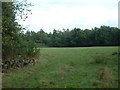
Bellowspipe Wood
Looking south east. The OS maps show the wood to be full of 'structures' in a very regular pattern, but there is no visible clue as to what they are for. Pigs, maybe?
Update: September 2007. John M has pointed out that the nearby Trading Estate was used as a munitions depot at one time - it seems likely that the structures were storage bunkers. See Image
Image: © David Medcalf
Taken: 14 Sep 2006
0.07 miles
3
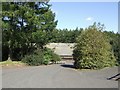
Poultry units
Hidden away on the edge of the woodland.
Image: © John M
Taken: 25 Aug 2007
0.12 miles