IMAGES TAKEN NEAR TO
Oakwood Road, BRIDGNORTH, WV16 6TD
Introduction
This page details the photographs taken nearby to Oakwood Road, WV16 6TD by members of the Geograph project.
The Geograph project started in 2005 with the aim of publishing, organising and preserving representative images for every square kilometre of Great Britain, Ireland and the Isle of Man.

There are currently over 7.5m images from over14,400 individuals and you can help contribute to the project by visiting https://www.geograph.org.uk
Image Map
Images are licensed for reuse under creativecommons.org/licenses/by-sa/2.0
Notes
- Clicking on the map will re-center to the selected point.
- The higher the marker number, the further away the image location is from the centre of the postcode.
Image Listing (3 Images Found)
Images are licensed for reuse under creativecommons.org/licenses/by-sa/2.0
Image
Details
Distance
2
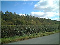
Woodland edge, Ditton Priors
The wood is on the site of a Royal Navy armaments depot, later used by US forces until closure in 1968. There is a timber works in the foreground behind a rather high hedge.
Image: © Richard Webb
Taken: 30 Jun 2014
0.20 miles
3

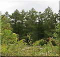
Barley beneath Brown Clee
Arable land near Ditton Priors.
Image: © Richard Webb
Taken: 30 Jun 2014
0.22 miles