IMAGES TAKEN NEAR TO
Brown Clee Road, BRIDGNORTH, WV16 6ST
Introduction
This page details the photographs taken nearby to Brown Clee Road, WV16 6ST by members of the Geograph project.
The Geograph project started in 2005 with the aim of publishing, organising and preserving representative images for every square kilometre of Great Britain, Ireland and the Isle of Man.

There are currently over 7.5m images from over14,400 individuals and you can help contribute to the project by visiting https://www.geograph.org.uk
Image Map
Images are licensed for reuse under creativecommons.org/licenses/by-sa/2.0
Notes
- Clicking on the map will re-center to the selected point.
- The higher the marker number, the further away the image location is from the centre of the postcode.
Image Listing (7 Images Found)
Images are licensed for reuse under creativecommons.org/licenses/by-sa/2.0
Image
Details
Distance
1

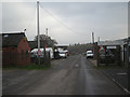
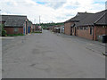
Trading Estate
The Trading Estate is next to the old railway built in 1908 to transport basalt quarried on the Brown Clee to join the main line at Cleobury Mortimer 12 miles away. Quarrying finished in 1936 when the basalt was exhausted. With the outbreak of war in 1939 an Admiralty munitions depot was established on the site. This remained in use until 1965 when the railway also closed. The site was briefly used again in 1967 and 1968 by the American Army when they were forced to vacate their bases in France.
Image: © John M
Taken: 25 Aug 2007
0.07 miles
2
Entrance to Ditton Priors Trading Estate
It seems hard to believe that this place was once a target for a Soviet nuclear missile but it was. The US kept ammunition here during and shortly after WW2 & for that reason (and maybe others) it became a nuclear target.
Image: © Row17
Taken: 3 Nov 2008
0.07 miles
3
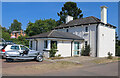
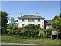
The Willows Cafe, Ditton Priors
Good food here. The building is a concrete structure but is not listed. There are a few round here. The silver three wheel car is a Berkeley T60 built in 1960 that appears to have been rebuilt with a Citroen 2CV power unit.
Image: © Chris Allen
Taken: 8 Jun 2023
0.07 miles
4
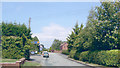
Ditton Priors: site of former station
View NE on the road to Middleton Priors: the terminus of the Cleobury Mortimer & Ditton Priors Light Railway had been on the right. The line from Cleobury Mortimer had been closed to passenger traffic since 26/9/38 (to goods since 11/9/39), but had then been acquired by the War Department to serve Armaments Depots at Ditton Priors until 30/6/65. Since then the station site has been a Trading Estate.
Image: © Ben Brooksbank
Taken: 27 Jun 2004
0.07 miles
5
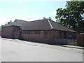
Ditton Priors Village Hall
On the site of the old railway station.
Image: © John M
Taken: 25 Aug 2007
0.08 miles
6
Trading estate at Ditton Priors
Looking south off Station Road through the entrance to the trading estate. Behind the village hall on the right was the terminus of the Cleobury Mortimer & Ditton Priors Light Railway and the trading estate occupies the goods yard. The 12-mile railway was opened in 1908 to transport dhustone from the Clee Hills quarries. By the Second World War, the stone supply was being worked out but the site was revived when the Naval Armament Depot was established here. The railway closed in 1960 and the Admiralty closed the depot in 1965. The site had a final brief revival in 1967-8 when the US Army was temporarily housed here following their forced evacuation from France.
http://en.wikipedia.org/wiki/Cleobury_Mortimer_and_Ditton_Priors_Light_Railway
Image: © Trevor Rickard
Taken: 22 Aug 2010
0.08 miles
7
Concrete house
Oak Farm No 2 is typical of the precast concrete houses built by the Abdon Clee Stone Company in the 1920s and 1930s. Estates of houses using this panel system were built in Wolverhampton and Neasden.
The panels were cast in a yard next to the station using basalt quarried on the Brown Clee.
Image: © John M
Taken: 25 Aug 2007
0.12 miles