IMAGES TAKEN NEAR TO
Monkhopton, BRIDGNORTH, WV16 6SB
Introduction
This page details the photographs taken nearby to WV16 6SB by members of the Geograph project.
The Geograph project started in 2005 with the aim of publishing, organising and preserving representative images for every square kilometre of Great Britain, Ireland and the Isle of Man.

There are currently over 7.5m images from over14,400 individuals and you can help contribute to the project by visiting https://www.geograph.org.uk
Image Map
Images are licensed for reuse under creativecommons.org/licenses/by-sa/2.0
Notes
- Clicking on the map will re-center to the selected point.
- The higher the marker number, the further away the image location is from the centre of the postcode.
Image Listing (13 Images Found)
Images are licensed for reuse under creativecommons.org/licenses/by-sa/2.0
Image
Details
Distance
1
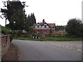
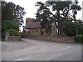
Home Farm Cottages, Monkhopton
Double fronted mock Tudor.
Image: © Anthony Vosper
Taken: 28 Jul 2011
0.01 miles
2
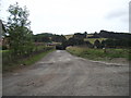
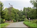
Track to Home Farm, Monkhopton
Not recommended for a low sports car.
Image: © Anthony Vosper
Taken: 28 Jul 2011
0.02 miles
3
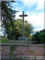
Monkhopton War Memorial
Originally erected in 1921, with restoration work carried out in 2000. The base is made from an old cider press stone, whilst the shaft and cross are oak and the memorial is to two local men who died in the first World War. Grade II listed https://britishlistedbuildings.co.uk/101459122-monkhopton-war-memorial-monkhopton#.YhZymujP3IU & https://historicengland.org.uk/listing/the-list/list-entry/1459122 in 2018.
Image: © Richard Law
Taken: 30 Oct 2021
0.02 miles
4
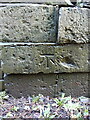
OS benchmark - Monkhopton church gate
An OS cutmark at the base of the gateway into the church yard from the road; last levelled by the OS in 1973 at 130.755m above Ordnance Datum Newlyn.
Image: © Richard Law
Taken: 30 Oct 2021
0.03 miles
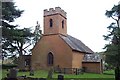
5
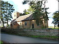
St Peter's Church, Monkhopton
A rather fine village church, with traces of its original 12th century structure still visible, particularly in some of the window openings. The tower was built in 1835. Grade II* listed https://britishlistedbuildings.co.uk/101367522-church-of-st-peter-monkhopton#.YhZ3tujP3IU & https://historicengland.org.uk/listing/the-list/list-entry/1367522 in 1970.
Image: © Richard Law
Taken: 30 Oct 2021
0.04 miles
6
St Peter's Church, Monkhopton
Like many others sadly locked.
Image: © Anthony Vosper
Taken: 28 Jul 2011
0.04 miles
7

Ordnance Survey Cut Mark
This OS cut mark can be found on the gatepost of St Peter's Church. It marks a point 130.755m above mean sea level.
Image: © Adrian Dust
Taken: 13 Mar 2017
0.04 miles
9
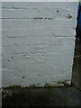
OS benchmark - Monkhopton, house east of the road
An OS cutmark on the wall of one of the cottages on the southern side of Monkhopton, last levelled by the OS in 1973 at 132.744m above Ordnance datum Newlyn.
Image: © Richard Law
Taken: 30 Oct 2021
0.08 miles