IMAGES TAKEN NEAR TO
Cleobury North, BRIDGNORTH, WV16 6RW
Introduction
This page details the photographs taken nearby to WV16 6RW by members of the Geograph project.
The Geograph project started in 2005 with the aim of publishing, organising and preserving representative images for every square kilometre of Great Britain, Ireland and the Isle of Man.

There are currently over 7.5m images from over14,400 individuals and you can help contribute to the project by visiting https://www.geograph.org.uk
Image Map
Images are licensed for reuse under creativecommons.org/licenses/by-sa/2.0
Notes
- Clicking on the map will re-center to the selected point.
- The higher the marker number, the further away the image location is from the centre of the postcode.
Image Listing (60 Images Found)
Images are licensed for reuse under creativecommons.org/licenses/by-sa/2.0
Image
Details
Distance
1
Ford at Cleobury North
This dry ford is found on a track at Cleobury North.
Image: © John Walton
Taken: 1 Aug 2015
0.02 miles
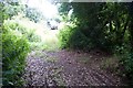
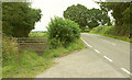
2
Former railway line, Cleobury North
A permissive path follows the right-hand track along the course of the dismantled Cleobury Mortimer and Ditton Priors Light Railway. The left-hand track leads to Mill Farm. Seen across the B4364.
Image: © Derek Harper
Taken: 28 Jul 2019
0.06 miles
3
Dismantled railway line, Cleobury North
Unlike Image], across the B4364 behind the camera, no right of way, permissive or otherwise, runs along this stretch of the course of the Cleobury Mortimer and Ditton Priors Light Railway.
Image: © Derek Harper
Taken: 28 Jul 2019
0.08 miles
4
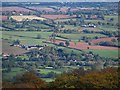
Cleobury North
View from the Brown Clee.
Image: © Richard Webb
Taken: 22 Oct 2010
0.08 miles
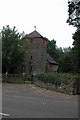
5
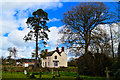
The Old Rectory, Cleobury North
Next to the church and safely listed Grade II.
Image: © Philip Pankhurst
Taken: 5 Apr 2016
0.11 miles
6
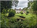
The Old Rectory (Cleobury North)
Here is the Old Rectory at Cleobury North, viewed from a public footpath to the east. This grade II listed structure was built around the late C18, and is adjacent to the parish church of St. Peter and St. Paul.
Image: © Fabian Musto
Taken: 12 Jul 2024
0.12 miles
7
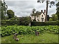
The Old Rectory (Cleobury North)
Here is the Old Rectory at Cleobury North, viewed from the churchyard at the parish church of St. Peter and St. Paul. This grade II listed structure was built around the late C18.
Image: © Fabian Musto
Taken: 12 Jul 2024
0.12 miles
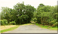
8
B4364 near Glebe Farm
The farm is just around the corner. This looks right from Image According to the map, bridleway 0119 10/1 should go through this gate rather than the one shown in that image.
Image: © Derek Harper
Taken: 28 Jul 2019
0.12 miles
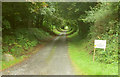
9
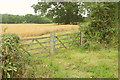
Gates onto bridleway near Glebe Farm
Bridleway 0119 10/1 leaves the B4364 and runs up the right side of the field of barley. All I can say is, if you're embarking upon it, good luck. The mile north of here took me an hour, coming in the opposite direction.
Image: © Derek Harper
Taken: 28 Jul 2019
0.12 miles