IMAGES TAKEN NEAR TO
Burwarton, BRIDGNORTH, WV16 6QW
Introduction
This page details the photographs taken nearby to WV16 6QW by members of the Geograph project.
The Geograph project started in 2005 with the aim of publishing, organising and preserving representative images for every square kilometre of Great Britain, Ireland and the Isle of Man.

There are currently over 7.5m images from over14,400 individuals and you can help contribute to the project by visiting https://www.geograph.org.uk
Image Map
Images are licensed for reuse under creativecommons.org/licenses/by-sa/2.0
Notes
- Clicking on the map will re-center to the selected point.
- The higher the marker number, the further away the image location is from the centre of the postcode.
Image Listing (3 Images Found)
Images are licensed for reuse under creativecommons.org/licenses/by-sa/2.0
Image
Details
Distance
2
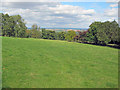
Sheep pasture near Chapelwood Farm
Looking north-east towards the Severn Valley around Bridgnorth in the distance. Much of the lower eastern slope of Brown Clee Hill is occupied by Burwarton Park grassland, dotted with mature trees. The B4364 is behind the hedge on the right.
Image: © Trevor Rickard
Taken: 22 Aug 2010
0.17 miles
3
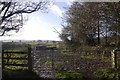
Muddy field, Loughton
View towards Titterstone Clee from a lane near Burwarton.
Image: © Richard Webb
Taken: 15 Feb 2018
0.23 miles