IMAGES TAKEN NEAR TO
Blackford, BRIDGNORTH, WV16 6QS
Introduction
This page details the photographs taken nearby to Blackford, WV16 6QS by members of the Geograph project.
The Geograph project started in 2005 with the aim of publishing, organising and preserving representative images for every square kilometre of Great Britain, Ireland and the Isle of Man.

There are currently over 7.5m images from over14,400 individuals and you can help contribute to the project by visiting https://www.geograph.org.uk
Image Map
Images are licensed for reuse under creativecommons.org/licenses/by-sa/2.0
Notes
- Clicking on the map will re-center to the selected point.
- The higher the marker number, the further away the image location is from the centre of the postcode.
Image Listing (9 Images Found)
Images are licensed for reuse under creativecommons.org/licenses/by-sa/2.0
Image
Details
Distance
1
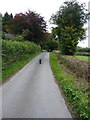
Dog on a mission
Heading up Thorn Lane to the small Methodist Chapel at Blackford.
Image: © Richard Law
Taken: 24 Sep 2017
0.11 miles
2
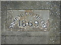
Datestone on the front gable of the Batch Methodist Chapel
The original carved stone (1869) sits amongst the stucco work on the gable end.
Image: © Richard Law
Taken: 24 Sep 2017
0.13 miles
3
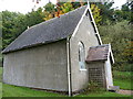
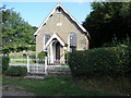
Blackford Methodist Chapel
Dating from 1869 Image, this tiny chapel was Grade II listed https://www.britishlistedbuildings.co.uk/101383751-methodist-chapel-at-ngr-so-598-830-stoke-st-milborough in 1998, and is still much as originally built both internally and externally. It's very similar in size and style to the one at Image
Image: © Richard Law
Taken: 24 Sep 2017
0.13 miles
4
Blackford Chapel
Despite being in a quiet rural area Blackford Chapel appears to have an active congregation.
Image: © Michael Patterson
Taken: 8 Aug 2006
0.14 miles
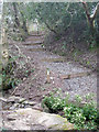
6

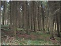
Steep Hill Bridleway
This bridleway drops down into a steep valley. The stream in the valley flows into Ledwyche Brook.
Image: © Michael Patterson
Taken: 8 Aug 2006
0.18 miles
7
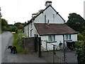
No 8 Thorn Lane (Chapel House)
A small cottage at Blackford, marked as number 8 on the maps, but apparently now also known as Chapel House.
Image: © Richard Law
Taken: 24 Sep 2017
0.20 miles
8
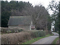
Old Lodge Coppice
The southern end of the Brown Clee woodlands.
Image: © Richard Webb
Taken: 26 Dec 2012
0.21 miles