IMAGES TAKEN NEAR TO
Loughton, BRIDGNORTH, WV16 6QR
Introduction
This page details the photographs taken nearby to WV16 6QR by members of the Geograph project.
The Geograph project started in 2005 with the aim of publishing, organising and preserving representative images for every square kilometre of Great Britain, Ireland and the Isle of Man.

There are currently over 7.5m images from over14,400 individuals and you can help contribute to the project by visiting https://www.geograph.org.uk
Image Map
Images are licensed for reuse under creativecommons.org/licenses/by-sa/2.0
Notes
- Clicking on the map will re-center to the selected point.
- The higher the marker number, the further away the image location is from the centre of the postcode.
Image Listing (16 Images Found)
Images are licensed for reuse under creativecommons.org/licenses/by-sa/2.0
Image
Details
Distance
1
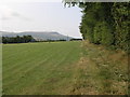
Sheep and Clee Hill
A footpath runs along the side of this field and joins with a network of many other paths in this area.
Image: © Michael Patterson
Taken: 8 Aug 2006
0.09 miles
2
Bridge over a small stream
The stream here drains from the south side of Clee Burf through a part of the Burwarton Estate, and joins the Ledwyche Brook near Cleedownton.
Image: © Richard Law
Taken: 24 Sep 2017
0.10 miles
3
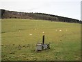
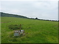
A galvanised trough
Drinking water for livestock in pasture on the slopes of Brown Clee.
Image: © Richard Webb
Taken: 26 Dec 2012
0.12 miles
4
Line of a footpath
Pretty much invisible on the ground, but marked by gates & stiles in the hedges, the path across here runs up the slope of the Clee Hill towards Banbury Covert.
Image: © Richard Law
Taken: 24 Sep 2017
0.15 miles
5
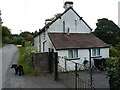
No 8 Thorn Lane (Chapel House)
A small cottage at Blackford, marked as number 8 on the maps, but apparently now also known as Chapel House.
Image: © Richard Law
Taken: 24 Sep 2017
0.16 miles
6
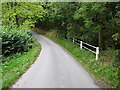
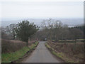
Thorn Lane towards B4364
View down Thorn Lane towards B4364 and beyond
Image: © Rob Bainbridge
Taken: 24 Apr 2022
0.18 miles
7
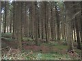
Old Lodge Coppice
The southern end of the Brown Clee woodlands.
Image: © Richard Webb
Taken: 26 Dec 2012
0.18 miles
8
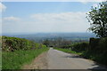
Down the hill to the junction
Had it been clear the view ahead would be of the Severn Valley all the way to the Clent Hills near Birmingham.
Image: © Row17
Taken: 2 Mar 2009
0.21 miles
9
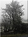
Densely frosted tree
This tree is alongside the B4364 on a mile-long stretch whose surroundings had a thickly frosted appearance. Elsewhere, the fields were thawed and green.
See also Image and Image
Image: © Chris Downer
Taken: 16 Dec 2007
0.22 miles
10
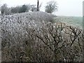
Pocket of iciness on the B4364
This hedge is about halfway along a mile-or-so stretch of the B4364 which this morning had a white appearance. Even approaching noon, the frost was in no hurry to clear. Either side of this mile-long patch, the fields were green.
Image: © Chris Downer
Taken: 16 Dec 2007
0.23 miles