IMAGES TAKEN NEAR TO
Wheathill, BRIDGNORTH, WV16 6QF
Introduction
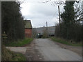
This page details the photographs taken nearby to WV16 6QF by members of the Geograph project.
The Geograph project started in 2005 with the aim of publishing, organising and preserving representative images for every square kilometre of Great Britain, Ireland and the Isle of Man.

There are currently over 7.5m images from over14,400 individuals and you can help contribute to the project by visiting https://www.geograph.org.uk
Image Map
Images are licensed for reuse under creativecommons.org/licenses/by-sa/2.0
Notes
- Clicking on the map will re-center to the selected point.
- The higher the marker number, the further away the image location is from the centre of the postcode.
Image Listing (4 Images Found)
Images are licensed for reuse under creativecommons.org/licenses/by-sa/2.0
Image
Details
Distance
2
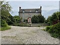
Upper Bromdon Farm
This lovely farmhouse is in a small hamlet nestling between the two Clee hills. The mixture of stone and brickwork make for a really attractive and unique building. Lucky people who live in it!
Image: © Andrew Shannon
Taken: 21 May 2024
0.21 miles
3
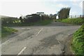
Drive to Goldthorn Farm
At the junction of minor roads the driveway to Goldthorn Farm makes the fourth arm. The side of Titterstone Clee Hill can be seen on the left.
Image: © David Luther Thomas
Taken: 20 Jan 2007
0.22 miles