IMAGES TAKEN NEAR TO
Midwinters, BRIDGNORTH, WV16 6PW
Introduction
This page details the photographs taken nearby to Midwinters, WV16 6PW by members of the Geograph project.
The Geograph project started in 2005 with the aim of publishing, organising and preserving representative images for every square kilometre of Great Britain, Ireland and the Isle of Man.

There are currently over 7.5m images from over14,400 individuals and you can help contribute to the project by visiting https://www.geograph.org.uk
Image Map
Images are licensed for reuse under creativecommons.org/licenses/by-sa/2.0
Notes
- Clicking on the map will re-center to the selected point.
- The higher the marker number, the further away the image location is from the centre of the postcode.
Image Listing (3 Images Found)
Images are licensed for reuse under creativecommons.org/licenses/by-sa/2.0
Image
Details
Distance
1
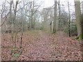
Chorley Covert
A path, before it gets very muddy.
Image: © Richard Webb
Taken: 14 Feb 2015
0.11 miles
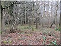
3
Felled area, Chorley Covert
Mixed woodland on very heavy soils, a remnant of the days when the Wyre Forest was much larger than today. Conifers were removed from this area.
Image: © Richard Webb
Taken: 14 Feb 2015
0.18 miles