IMAGES TAKEN NEAR TO
Billingsley, BRIDGNORTH, WV16 6PG
Introduction
This page details the photographs taken nearby to WV16 6PG by members of the Geograph project.
The Geograph project started in 2005 with the aim of publishing, organising and preserving representative images for every square kilometre of Great Britain, Ireland and the Isle of Man.

There are currently over 7.5m images from over14,400 individuals and you can help contribute to the project by visiting https://www.geograph.org.uk
Image Map
Images are licensed for reuse under creativecommons.org/licenses/by-sa/2.0
Notes
- Clicking on the map will re-center to the selected point.
- The higher the marker number, the further away the image location is from the centre of the postcode.
Image Listing (14 Images Found)
Images are licensed for reuse under creativecommons.org/licenses/by-sa/2.0
Image
Details
Distance
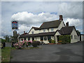
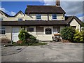
1
The Cape Of Good Hope, Billingsley
A Banks's pub by the B4363 Bridgnorth road.
Image: © Jonathan Billinger
Taken: 30 Jul 2007
0.01 miles
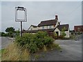
2
Closed pub named The Cape of Good Hope
There are several pictures of this pub in better times Image], now it's closed and looks rather forlorn. Not sure when is closed.
Image: © Philip Halling
Taken: 28 Aug 2018
0.02 miles
3
Closed pub named The Cape of Good Hope
There are several pictures of this pub in better times Image], now it's closed and looks rather forlorn. Not sure when is closed.
Image: © Philip Halling
Taken: 28 Aug 2018
0.02 miles
4
The Cape of Good Hope Pub, Billingsley, has seen better days
Image: © Rob Purvis
Taken: 14 Jun 2018
0.02 miles
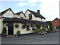
5
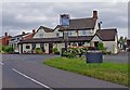
The Cape of Good Hope (1)
There are several pubs in England with this name. This one is in a quiet part of Shropshire, a few miles south of Bridgnorth. For such a sparsely populated area, there are still a surprising number of rural pubs around.
Image
Image
Image: © P L Chadwick
Taken: 10 Jul 2010
0.02 miles
6
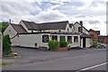
The Cape of Good Hope (2)
The pub was built in the early 19th century to serve the workers at the nearby large coal mine and blast furnace, which were close to Southall Bank Farm. These didn't survive many years, but late in the same century a new pit was sunk near to the pub. This pit didn't survive either but the pub has, and is now the focal point of what remains of the village. Originally the village centre was by the church, but that is now a mile away, with only a farm and a couple of cottages as neighbours.
Image
Image
Image: © P L Chadwick
Taken: 10 Jul 2010
0.02 miles
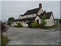
7
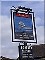
The Cape of Good Hope (pub sign)
The pub is on the B4363 road from Bridgnorth to Cleobury Mortimer. It is unusual for a Banks's pub, as it has an individual sign. The great majority of their pubs have a sign with the pub name above the Banks's gold lion. Whether this will change, now that Marstons have taken over, remains to be seen.
Image
Image
Image: © P L Chadwick
Taken: 10 Jul 2010
0.02 miles
8
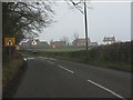
First glimpse of Billingsley on the B4363
Image: © Peter Whatley
Taken: 23 Mar 2012
0.03 miles
9
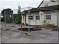
A hole in front of a closed pub
This hole has the appearance of a sinkhole, it is directly in front of closed The Cape of Good Hope' public house in Billingsley.
Image: © Philip Halling
Taken: 28 Aug 2018
0.03 miles