IMAGES TAKEN NEAR TO
Netherton Lane, BRIDGNORTH, WV16 6NE
Introduction
This page details the photographs taken nearby to Netherton Lane, WV16 6NE by members of the Geograph project.
The Geograph project started in 2005 with the aim of publishing, organising and preserving representative images for every square kilometre of Great Britain, Ireland and the Isle of Man.

There are currently over 7.5m images from over14,400 individuals and you can help contribute to the project by visiting https://www.geograph.org.uk
Image Map
Images are licensed for reuse under creativecommons.org/licenses/by-sa/2.0
Notes
- Clicking on the map will re-center to the selected point.
- The higher the marker number, the further away the image location is from the centre of the postcode.
Image Listing (11 Images Found)
Images are licensed for reuse under creativecommons.org/licenses/by-sa/2.0
Image
Details
Distance
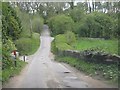
7
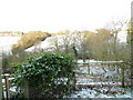
View over the Borle Valley in the snow
Image: © Anne Patterson
Taken: 2 Feb 2008
0.21 miles
10
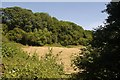
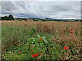
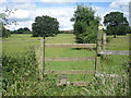
Field, Borlemill
After the silage harvest.
Image: © Richard Webb
Taken: 3 Jul 2018
0.22 miles