IMAGES TAKEN NEAR TO
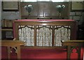
Church Lane, BRIDGNORTH, WV16 6NB
Introduction
This page details the photographs taken nearby to Church Lane, WV16 6NB by members of the Geograph project.
The Geograph project started in 2005 with the aim of publishing, organising and preserving representative images for every square kilometre of Great Britain, Ireland and the Isle of Man.

There are currently over 7.5m images from over14,400 individuals and you can help contribute to the project by visiting https://www.geograph.org.uk
Image Map
Images are licensed for reuse under creativecommons.org/licenses/by-sa/2.0
Notes
- Clicking on the map will re-center to the selected point.
- The higher the marker number, the further away the image location is from the centre of the postcode.
Image Listing (72 Images Found)
Images are licensed for reuse under creativecommons.org/licenses/by-sa/2.0
Image
Details
Distance
1
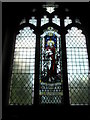
Stained glass window above the altar at St Mary, Highley
Image: © Basher Eyre
Taken: 11 Aug 2009
0.00 miles
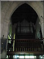
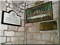
3
1939-1945 war memorial within St Mary, Highley
Image: © Basher Eyre
Taken: 11 Aug 2009
0.03 miles
8
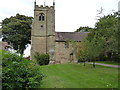
St Mary's Highley
The parish church of Highley.
Image: © Richard Law
Taken: 24 Sep 2016
0.04 miles
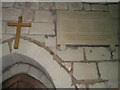
9
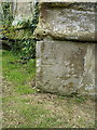
OS benchmark - Highley, St Mary's church tower
An OS cutmark on the buttress at the NW corner of the tower; originally levelled at 99.557m above Ordnance Datum Newlyn, probably in 1960.
Image: © Richard Law
Taken: 24 Sep 2016
0.04 miles
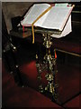
10
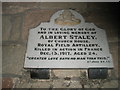
Poignant memorial within St Mary, Highley
Image: © Basher Eyre
Taken: 11 Aug 2009
0.04 miles