IMAGES TAKEN NEAR TO
Rhea Hall Estate, BRIDGNORTH, WV16 6LE
Introduction
This page details the photographs taken nearby to Rhea Hall Estate, WV16 6LE by members of the Geograph project.
The Geograph project started in 2005 with the aim of publishing, organising and preserving representative images for every square kilometre of Great Britain, Ireland and the Isle of Man.

There are currently over 7.5m images from over14,400 individuals and you can help contribute to the project by visiting https://www.geograph.org.uk
Image Map
Images are licensed for reuse under creativecommons.org/licenses/by-sa/2.0
Notes
- Clicking on the map will re-center to the selected point.
- The higher the marker number, the further away the image location is from the centre of the postcode.
Image Listing (58 Images Found)
Images are licensed for reuse under creativecommons.org/licenses/by-sa/2.0
Image
Details
Distance
1
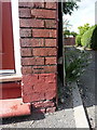
OS benchmark - Highley, 37 Barke Street
An OS cutmark on the wall of a house at the crest of the hill on Barke Street. It was originally levelled, probably in 1960, at 112.989m above Ordnance Datum Newlyn.
Image: © Richard Law
Taken: 26 Aug 2017
0.03 miles
2
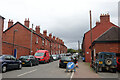
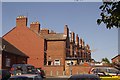
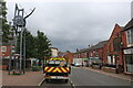
Orchard Street, Highley
Working class terraced housing in this former mining community.
Image: © Chris Allen
Taken: 19 Sep 2021
0.05 miles
3
The back of Barke Street, Highley
Terraced houses in this former mining community.
Image: © Chris Allen
Taken: 19 Sep 2021
0.05 miles
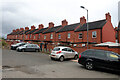
4
Barke Street, Highley
Highley owes its size and appearance to the Wyre Forest coalfield and its collieries.
Image: © Richard Webb
Taken: 3 Jul 2018
0.07 miles
5
Houses, Barke Street
A row of extensions at the back of a terrace in Highley.
Image: © Richard Webb
Taken: 3 Jul 2018
0.07 miles
6
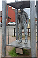
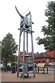
Highley Clock Tower, 1999
Commemorating Highley's coal mining past. This is a representation of a miner in a cage.
Image: © Chris Allen
Taken: 19 Sep 2021
0.08 miles
7
Clock, High Street, Arley
This is a reminder of Arley's coal mining past. At the bottom is a representation of a miner in a winding cage.
Image: © Chris Allen
Taken: 19 Sep 2021
0.08 miles
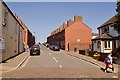
8
High Street, Highley
On the left is the mining themed clock that commemorates Highley's past as a mining community.
Image: © Chris Allen
Taken: 19 Sep 2021
0.08 miles
9
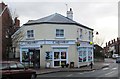
Costcutter supermarket, Hawthorne House, High Street, Highley, Shrops
The Paper Shop, a newsagents, used to be here but now a small supermarket operates here. It is part of the Costcutter chain of convenience stores and supermarkets. They are independently owned but benefit from the Costcutter branding and supply of products.
Image: © P L Chadwick
Taken: 10 Dec 2014
0.08 miles
10
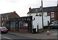
Skippers Fish Bar, 1 High Street, Highley, Shrops
A fish and chip shop, which also sells kebabs, burgers, pies and much else.
Image: © P L Chadwick
Taken: 10 Dec 2014
0.08 miles