IMAGES TAKEN NEAR TO
Vicarage Lane, BRIDGNORTH, WV16 6JS
Introduction
This page details the photographs taken nearby to Vicarage Lane, WV16 6JS by members of the Geograph project.
The Geograph project started in 2005 with the aim of publishing, organising and preserving representative images for every square kilometre of Great Britain, Ireland and the Isle of Man.

There are currently over 7.5m images from over14,400 individuals and you can help contribute to the project by visiting https://www.geograph.org.uk
Image Map
Images are licensed for reuse under creativecommons.org/licenses/by-sa/2.0
Notes
- Clicking on the map will re-center to the selected point.
- The higher the marker number, the further away the image location is from the centre of the postcode.
Image Listing (5 Images Found)
Images are licensed for reuse under creativecommons.org/licenses/by-sa/2.0
Image
Details
Distance
1
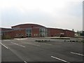
The Severn Centre, Highley
The newly completed leisure complex at Highley
Image: © David Stowell
Taken: 24 Apr 2005
0.10 miles
3
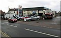
Highley Garage, High Street, Highley, Shrops
A local garage which is also a MOT Test Centre. It is one of the minority of garages which sell LPG fuel.
Image: © P L Chadwick
Taken: 10 Dec 2014
0.22 miles
4
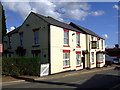
The Bache Arms in Highley
This public house located on the High Street of Highley became a pub in 1839 and was formerly called the New Inn. It was later named after the Bache family who were long term tenants.
Image: © Mat Fascione
Taken: 25 Jul 2024
0.23 miles
5
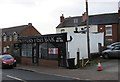
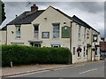
Skippers Fish Bar, 1 High Street, Highley, Shrops
A fish and chip shop, which also sells kebabs, burgers, pies and much else.
Image: © P L Chadwick
Taken: 10 Dec 2014
0.24 miles