IMAGES TAKEN NEAR TO
Bridgnorth Road, BRIDGNORTH, WV16 6HE
Introduction
This page details the photographs taken nearby to Bridgnorth Road, WV16 6HE by members of the Geograph project.
The Geograph project started in 2005 with the aim of publishing, organising and preserving representative images for every square kilometre of Great Britain, Ireland and the Isle of Man.

There are currently over 7.5m images from over14,400 individuals and you can help contribute to the project by visiting https://www.geograph.org.uk
Image Map
Images are licensed for reuse under creativecommons.org/licenses/by-sa/2.0
Notes
- Clicking on the map will re-center to the selected point.
- The higher the marker number, the further away the image location is from the centre of the postcode.
Image Listing (18 Images Found)
Images are licensed for reuse under creativecommons.org/licenses/by-sa/2.0
Image
Details
Distance
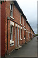
1
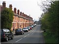
Woodhill, Highley
A row of what were probably miners houses in the former colliery area
Image: © David Stowell
Taken: 24 Apr 2005
0.03 miles
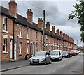
3
Clee View, Highley
A row of terraced workers' houses in this former mining community.
Image: © Chris Allen
Taken: 19 Sep 2021
0.04 miles
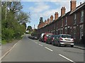
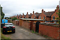
4
Terraced housing along Woodhill Road, Woodhill
This row of terraced housing is Clee View, built by the Highley Mining Company for the workers of the former Highley Colliery.
Image: © Mat Fascione
Taken: 25 Jul 2024
0.04 miles
5
Clee View, Highley
Terraced workers' housing in this former mining settlement.
Image: © Chris Allen
Taken: 19 Sep 2021
0.05 miles
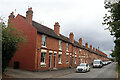
6
The back of Clee View, Highley
A group of terraced workers' houses in this former mining community.
Image: © Chris Allen
Taken: 19 Sep 2021
0.05 miles
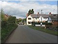
8
The Malt Shovel at Highley
This pub claims to have the best views in Shropshire.
Image: © Row17
Taken: 8 Nov 2008
0.14 miles
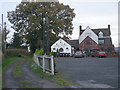
9
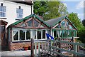
The Malt Shovel (2) - rear, Woodhill Road, Highley, Shrops
Part of the rear of the public house and of the rear terrace.
See also:- Image
Image: © P L Chadwick
Taken: 20 May 2018
0.14 miles
10
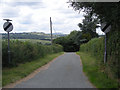
Lane to the ford
The distinctive outline of Titterstone Clee Hill can be seen in the distance.
Image: © Row17
Taken: 4 Jul 2008
0.15 miles