IMAGES TAKEN NEAR TO
Occupation Lane, BRIDGNORTH, WV16 6BE
Introduction
This page details the photographs taken nearby to Occupation Lane, WV16 6BE by members of the Geograph project.
The Geograph project started in 2005 with the aim of publishing, organising and preserving representative images for every square kilometre of Great Britain, Ireland and the Isle of Man.

There are currently over 7.5m images from over14,400 individuals and you can help contribute to the project by visiting https://www.geograph.org.uk
Image Map
Images are licensed for reuse under creativecommons.org/licenses/by-sa/2.0
Notes
- Clicking on the map will re-center to the selected point.
- The higher the marker number, the further away the image location is from the centre of the postcode.
Image Listing (5 Images Found)
Images are licensed for reuse under creativecommons.org/licenses/by-sa/2.0
Image
Details
Distance
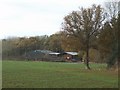
1
White farmhouse
There are no windows on the north elevation of this building, adjacent to the bridleway.
Image: © John M
Taken: 11 Nov 2007
0.06 miles
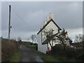
2
Green lane
I find it curious how some lanes have become part of the highway network and others such as this near Chelmarsh leading to the church that remain as bridleways only.
Image: © John M
Taken: 11 Nov 2007
0.06 miles
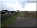
3
Pasture land near Chelmarsh
The curious scarecrow is a builders material sack wrapped around a concrete post.
Image: © John M
Taken: 11 Nov 2007
0.09 miles
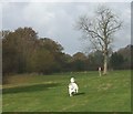
4
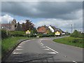
B4555 enters Chelmarsh from the south
Image: © Peter Whatley
Taken: 12 May 2012
0.20 miles